La Carretera Austral: The Gravel Road To The End Of The World
Pan-American Transmissions: Part 12
“Pan-American Transmissions” is a travel series from Special Contributor Diego Cupolo as he travels south from Nicaragua to Argentina. He has few plans, a $10-a-day budget and one flute-playing gypsy companion. Check back as new dispatches are posted from the road.
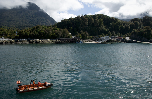
The overnight boat approached mainland Chile beneath the shadow of the Chaitén Volcano, a gaping caldera that erupted in 2008, burying the port below. Gray cinder still sat on the rooftops of abandoned houses along the coast and a thick sponge of ash floated in the water below us, forcing the captain to anchor offshore and wait until high tide in the early morning to dock safely.
Standing there, on the upper deck, I watched the sun rise over a jagged landscape so green it made the dismal ashtray of a town seem like a small footnote of human misfortune in a vast terrain of unspoiled natural beauty. This was Patagonia.
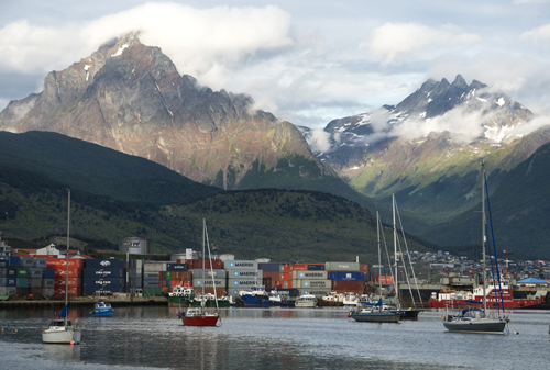
Around me, a strange mix of passengers waited anxiously to disembark. They were Czech film crews, Danish Hell’s Angels, Japanese mountaineers and cross-continental cyclists of all nationalities. We boarded in Chiloé and together we sailed through the night, bounded by one all-consuming, unreasonable need to reach the end of the world: Ushuaia.
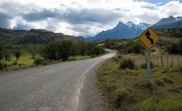
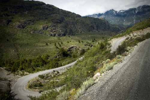
To reach this city at the southern tip of South America, one can choose between two paved Argentinian routes or Chile’s Carretera Austral, a 770-mile (1,240 km) stretch of mostly gravel mountain passages through the most vibrant and least inhabited regions of Patagonia. Having been completed in the early 1980’s, the road gave access to long isolated areas and locals like to call it the only good thing former dictator Pinochet ever did.
When our boat finally docked that morning in Chaitén, the fervent passengers rushed out down the highway like horses at the track. I, too, was fervent, but hungry, as well. Inside the town bakery, I gnawed two-day-old bread as I spoke with the lady behind the cash register, trying to get a sense for the route ahead. Traffic would be less than sparse, buses were few and all forms of transportation were severely expensive.
At that moment, I remembered a song by Joan Manuel Serrat. A friend had played it for me before I left Buenos Aires and he highlighted one verse in particular: “Caminante son tus huellas el camino y nada más; Caminante no hay camino, se hace camino al andar,” which roughly translated into, “Walker your footsteps are the path and nothing more; Walker there is no path, the path is made by walking.
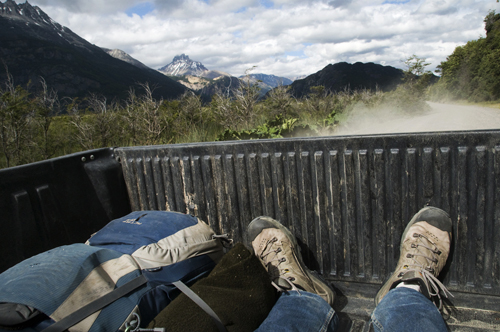
Standing in that bakery, stale terrible bread in hand, I decided to go down the Carretera Austral on foot. I’d accept the occasional lift — when there was one — but I would go on to spend the majority of the next month marching towards Ushuaia, the end of the road, a place I’d been trying to find ever since I got off training wheels.
This was it. Two legs, a 25-kilo backpack, a bag of oatmeal and a sack of powdered milk. Sixteen months after landing in Nicaragua, this grand Pan-American voyage was coming to a close.
Se Hace Camino al Andar: Down the Futaleufú to Queulat National Park
My instincts were right, but the direction was wrong. After the first day on the road I woke up in Futaleufú, a town near the Argentinian border, about 50 miles off course. I had spent the prior day in Parque Pumalín, one of many large conservation areas in southern Chile owned by North Face co-founder Douglas Tompkins, prompting suspicious locals to accuse him of creating some kind of secret Zionist state.
When I popped out of the bushes I caught a ride to with an Argentinean hippie couple heading to Futaleufú. I asked if the town was south on Carretera Austral and they said yes, but that was a lie. Stranded and with few options, I started walking back towards the highway. About four hours later, a truck hauling two rafts stopped and gave me a lift. The driver said he was starting a new whitewater rafting company and was about to shoot a promotional video.
“We need one more guy in the raft,” he said. “We’ll give you all the gear and drop you off downriver near the Carretera Austral free of charge. It’s your lucky day. Do you want to join us?”
I didn’t know it, but we were just next to the Futaleufú River, a world-renowned water sports destination with Class 5 rapids. I had only been whitewater rafting once before in Chattanooga, Tennessee, but agreed to go along because, hell, who wouldn’t? Suited up, with a yellow paddle in hand, I climbed into the raft with three guys that had Go Pro cameras attached to their helmets.
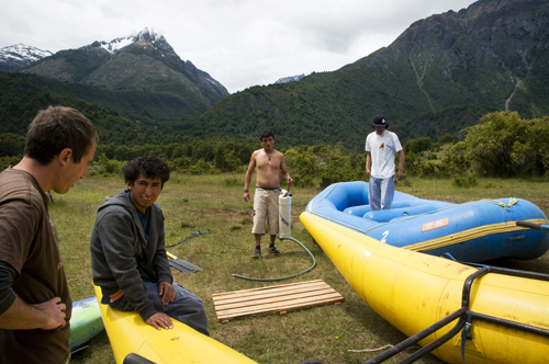
Together we floated down the bright turquoise river towards rapids with names like “The Terminator” and “The Himalayas.” As the raft approached the first set of rapids, a canyon of roaring white foam broken only by massive boulders, the guy in the back began shouting instructions. “Right side paddle! Stop! Left side paddle! Right paddle backwards! Everyone! Weight on the right!” Failing to follow commands meant flipping over.
For the next two hours I didn’t see much more than my paddle and white foam. At some points, the front end of the raft would go airborne and my paddle wasn’t long enough to reach the water below. At other points, violent waves crashed over the nose, blinding us for one second too long, leaving the raft at the mercy of the next wave. People do this for fun. Paddle or die.
By the end we were all howling like wolves. The final rapids were Class 4 and, well, I could actually enjoy those because I could see what lay ahead. We ran the whole course of the Futaleufú River — or “Big River” in the native Mapuche language — and as promised, the guys let me off near the Carretera Austral. Just like that I had gotten back on course. Completely drenched, freezing cold and still shaking with adrenaline, but back on course.

That night I camped on the side of the road with a retired baby boomer couple from Santiago that had picked me up in their Volkswagen RV. We drank Crown Royal and they showed me all the Apps of their new Samsung tablet. In the morning, the two dropped me off in Queulat National Park, where mountaintop glacier fields melt into a thousand waterfalls above misty Pacific rain forests, and an entire new day in Patagonia began to unfold.
I stashed my bag behind a fallen tree and hiked up the Bosque Encantado trail with a group of Israeli backpackers. Climbing in the light fog, we worked our way through a maze of green moss that connected every branch, stone and leaf, making the forest seem more like a single living organism than individual trees or plants.
After lunch it started to rain, as it often does along the Pacific coast. I grabbed my bag and continued south on the Carretera Austral. Rain soon turned to downpour, but I kept walking, using a big nalca leaf as an umbrella until I reached Piedra del Gato, a small gorge about 13 miles down the highway.
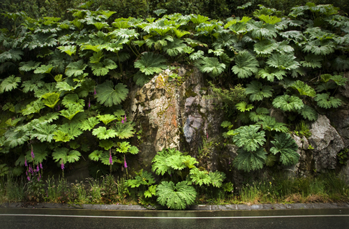
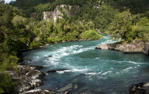
There, while I stood on the side of the road, looking down at the another set of turquoise river rapids, a local pulled over. His name was Erwin and he was a fisherman. He knew every island, mountain and river in southern Chile. From time to time, he worked as a helicopter guide for rich tourists looking to go “deep” into the mountains. Erwin laughed at me, standing in the rain with my nalca leaf umbrella and asked if I knew how to eat nalca.
“You can eat this?” I asked.
“Claro. Of course, but only the stem,” he said before jumping out of his old pick-up truck and finding a few plants.
Erwin said the best plants for consumption were young and had flexible stems. The taste peaks just before if the leaf opens. Erwin took a stem, shaved off the red spikes with a knife and cut me a piece. It tasted like celery, only more juicy and more bitter. Not bad.
“These grow in every rainy region of Patagonia. You can live on them,” he said. “You know, one time a 70-year-old man got lost in these woods and rescue squads couldn’t find him. About a month went by before they called off the search, assuming he was dead, but two months after that, the guy came out of the forest alive and well, having survived on a diet of nalca stems. He was 70 years old.”
“They’re also good for digestion,” he added as he took a bite. “If you have a stomach ache, they’ll probably make it go away.”
Erwin dropped me off outside Coyhaique where I dried my clothes over a campfire for the night. His advice on nalca plants and forest survival would prove more than valuable for the rest of the trip and I kept his number in case I ever have enough money for a Patagonian helicopter tour.
Son Tus Huellas el Camino: Coyhaique and Lago General Carrera
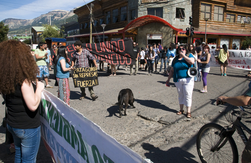
The apocalypse came and went and 2013 arrived as I reached Coyhaique, a city of 50,000 inhabitants. Civilization, at last. Internet cafes, organic quinoa cookies and teenage goth punks with lip piercings. I stayed with a local couchsurfer for a week as I conducted interviews and attended protests against HidroAysén, an $11 billion hydroelectric project that aims to build five dams in two of Patagonia’s largest rivers. One of several divisive issues in Chile at the moment.
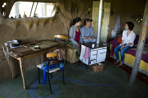
In the meantime, I also visited the autonomous communities rising along Coyhaique’s city limits. House prices in Patagonia can be astronomical, so a growing number of young people are buying small plots of land and building their own homes from scratch. The resulting off-the-grid villages sprouting up throughout southern Chile make for a compelling social experiment.
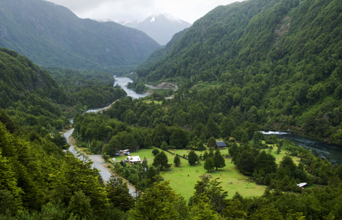
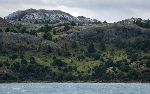
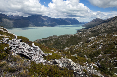
The slow country life and open-minded people made Coyhaique an easy place to stay for a while, but I had to keep moving and continued south as soon as I finished my research. Two days and three rides later, I passed through Reserva Nacional Cerro Castillo — the poor man’s Torres del Paine — and reached Lago General Carrera, Chile’s largest and probably most scenic lake.
Here, the Carretera Austral runs through some of the most beautiful landscapes in the world. No amount of open-mouth staring can suffice. I set up camp along the lakeshore in Puerto Rio Tranquilo and watched the pink cliffs melt slowly into cyan waters over and over again. A natural hypnosis.
The next morning came with a mess of rain. This was to become a recurring theme throughout the trip. In southern Chile, coastal areas are especially prone to showers while interior regions enjoy much drier weather. This is the case with Chile Chico, a town known for its pleasant Mediterranean micro-climate near the Argentinian border.
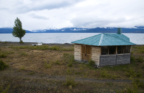
Hoping to get out of the rain, I made my way around the lake towards Chile Chico and arrived in Puerto Guadal, a small village on the verge of being abandoned. The streets were empty, all the windows were shut and the stores were closed. I tried knocking at the door of the grocery store, but no one answered.
Halfway to starving, I found two rotten apples in a trash pile behind the store and was considering them as a meal when a middle-aged woman appeared on the street. She was round, disheveled and walked in zig-zags. The first sign of life in the village. I approached her to ask about the store.
“Buenos dias, discuple,” I said to be polite. “Do you know if the grocery store is open at this time?”
She looked at me like snakes were coming out of my mouth. Her lips pressed shut and her eyes widened with manic confusion. She seemed disturbed by the sight of my face and kept watching me as she walked away without saying a word. As I write this, I still wonder what she saw during that long, strange moment. That kind of insanity is contagious and must thrive in these small mountain villages.
No one else passed for a while and then the store owner finally arrived. I entered bought my Patagonian staple food: bread and tubed cream cheese (the cheapest food in a region that produces little aside from meat). I ate as the rain became heavy again and then went on my way down Route 265 towards Chile Chico, to the dry weather everyone talked about.
I never made it. The showers made a stream of the gravel road and about four cars passed in the six hours I had been walking. The sun was setting and I was soaked again. Without a dry place to sleep, I took refuge in the barbecue hut of an empty vacation house, a structure locally known as a quincho. The door was unlocked and there was a stack of wood next to the grill so, well, I made a fire and hung my clothes to dry.
Adventure means going outside your comfort zone and considering all the wet, miserable places I could’ve ended up, the shelter of this quincho wasn’t bad at all.
The rain stopped the following morning and I woke up to a clear view of Lago General Carrera with snow-covered mountains on the opposite shore. You could say it was a well-placed vacation home. I collected driftwood to replace what I had used through the night, packed up, and once again made my way back to the Carretera Austral, abandoning any hopes of reaching Chile Chico.
Caminante no Hay Camino: Cochrane, Caleta Tortel and Villa O’Higgins
Through the final and least transited section of the highway, I spent many nights camping along riverbanks and many days walking non-stop, fueled by an abundance of nalca plants. Thanks Erwin. Though I was alone on foot, I had daily encounters with a trio of Chilean cyclists that were biking the entire road. We traveled at about the same pace and we often shared lunches, travel stories and all-important weather reports.
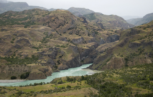
Locals say “those who hurry in Patagonia lose time,” and we made sure to go as slow as possible through the open country. After the night in the barbecue hut, I walked to Lago Bertrand and then south along the Rio Baker, one of the two rivers currently threatened by hydroelectric dams.
When I reached Cochrane, a town of 3,000, I stayed with another couchsurfer as I finished up a few more interviews on the HidroAysén project. My host was nice. He looked like Trent Reznor and made big, vegetarian meals, but he had just broken up with his long-time girlfriend and there were a few holes in his bedroom door at about fist level so I made sure to tread lightly and stay briefly.
The further south I went, the more “tavanos”, or giant horse flies, there were. The bastards like to bite and every time you kill one, ten more show up to fly around your head. Still, the scenery was incredible. I look back at my photos and, though I was there, I still cannot believe these places exist.
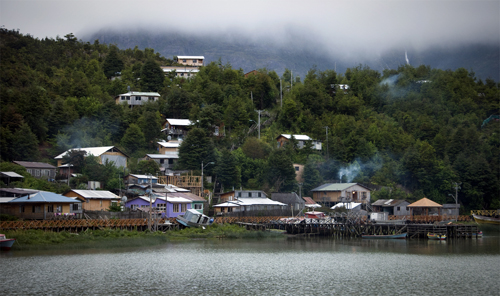
A good example was Caleta Tortel. The Chilean cyclist told me to visit the small port town, wedged between fjords on the Pacific shore, so I took a detour off the Carretera Austral towards the coast on a road that was completed only in 2003. On arrival, a maze of wooden plank stairways and walkways led through a strange settlement of stilt houses with smoking chimneys and tired sailors smoking pipes.
Among the seafarers was an Alaskan who sailed around the world three times in a 15-meter boat. He was old, didn’t smile much and had just come around Cape Horn on a straight shot from Norway. He said he once spent 78 days out on the sea, alone, while crossing the Pacific. His secret: an on board dutch oven for baking bread.
Aside from the sailors, Caleta Tortel was a little dull and overpriced, a consequence of heavy cruise ship tourism. I got back on the Carretera Austral, crossed the Rio Bravo on a free ferry and got picked up by a French couple on the other side. Together we drove through the rugged mountain valleys that make up the last 90 km of the highway. Along the way, we spotted a pair of local fishermen in the Rio Mayer and bought two mid-sized trouts for USD$3.00.
That night, the three of us cooked fish with rice over a campfire on the lakeshore and, well, life was good. We shared two bottles of wine and I learned they were Calculus majors visiting Chile for an international mathematics conference. You never know who you’ll find on the road.
In the morning we arrived at Villa O’ Higgins, the somber end of the Carreterra Austral. With just 500 residents, the village acts mainly as a backdoor entrance to Argentina. An expensive ferry, (about USD$80.00) provides sporadic transit across Lago O’ Higgins to Candelario Mancilla where travelers can hike about 20 miles over a several mountains to reach the nearest road in Argentina. Except for two military border checkpoints, there’s nothing out there. I pitched my tent and waited for the next ferry, collecting necessary provisions in the meantime.
Y Nada Más: Crossing to Argentina, Reaching Ushuaia
The journey down the Carretera Austral began and ended with a boat ride. Because of the Southern Chile’s rugged mountain terrain, there are no overland routes from Villa O’Higgins to Tierra del Fuego, forcing both travelers and locals to cross over to Argentina in order reach Chile’s southern tail.
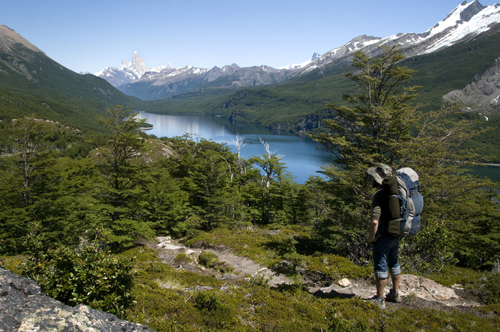
On a sunny Friday morning, I rode the ferry across Lago O’Higgins and shared one last lunch with the Chilean cyclists before setting off for Argentina. With 25 kilos of crap on my back, following this tiny trail up and down mountain valleys would make for one of the hardest hikes in my life.
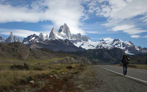
For two glorious days I walked in a silence broken only by the occasional crack of a mountaintop glacier. A sharp echo would bounce off the valley walls, and I’d look up just in time to see an avalanche of ice pour into the river below. In front of me, Mount Fitz Roy jutted into the sky like massive canine tooth of bedrock, and this handsome mountain served as a beacon for El Chaltén, the closest town in Argentina.
I camped on the shore of Lago del Desierto and hiked through the forest until I reached some kind of vacation resort on the opposite shore. It was packed with screaming children getting scorned by their screaming parents. Civilization once more. After that it was easy. All the Patagonian mega-attractions — El Chaltén, El Cafate, Torres del Paine National Park — were connected by wide, smooth highways, and as a result, they were filled with tourists and extremely high prices.
Of course, the scenery was amazing, but not much different from the landscapes along the Carretera Austral. The same was true for Ushuaia. Retired Swiss tourists filled the streets, paying top dollar for everything, from bread to bunk beds, all to see about the same sights anyone can enjoy in Chile, free of charge.
It’s sad when you realize your final destination is nothing more than a tourist trap, but, excuse the cliche, it was the journey that mattered. Few destinations in world can compare with the untamed wilderness in Southern Chile, and there’s no better way to experience it than by walking, biking or driving down the Carretera Austral. The key is to stop thinking, saving, planning and dreaming, and just go. The rest will work out. “Se hace camino al andar” can also mean “The path is made by going forward.”
To commemorate the end of the journey I shaved off my mountain beard in Ushuaia and threw it into the Beagle Channel, a passage named after the ship Charles Darwin boarded at this very same port to reach the Galapagos Islands. Without the funds to stay in town for more than two nights, I caught a lift back to Buenos Aires with a Brazilian truck driver and that was it. I flew back to Montreal to be with Ania again.
Looking back, Moving forward
Nicaragua to Tierra del Fuego. You’re supposed to have big, thoughtful observations after long expeditions into foreign lands. The world becomes smaller. Vague terms like “poverty” and “globalization” gain meaning. You change. The people around you change. Yet, still, it takes time to digest a year and half on the road.
For now, I’ll just say that throughout those long, peaceful days spent walking along the Carretera Austral, I’d look at the mountains, the rivers and the lakes and they seemed so separate from humanity, so indifferent to our presence. Through every war, dictatorship and mistake we ever made, those valleys remained the same. Untouched. I wanted to stay there for the rest of my life.
Not long after, I realized this observation was wrong and not simply because I was walking on a man-made highway. When I arrived in Tierra del Fuego, locals were in shock over the recent heat waves were hitting the Antarctic island. They never experienced such balmy weather patterns and the uncomfortable sweat on their brows came with tinge of fear.
With that thought, I rode back through the dry Argentinian plains and returned to North America. Traveling and having fun is great, but we — all seven billion of us — have a lot of work to do if we want to continue enjoying places like Patagonia and, in a broader sense, our time together on this tiny planet.
Thanks for reading.
By Diego Cupolo
Read all of the other Pan-American Transmissions entries here.

About the Author
 Diego Cupolo is a freelance photojournalist currently on the road to Tierra del Fuego. Most recently he served as Associate Editor for BushwickBK.com, an online newspaper in Brooklyn, and his work has appeared in The New Yorker, The Atlantic, The Star-Ledger, The Australian Times, Discover Magazine and many other publications. View more of his work at DiegoCupolo.com.