The post 10 Hiking Trails Around the World That Will Blow Your Mind appeared first on The Expeditioner Travel Site.
]]>
I have always been a nature person. Cities, for me, seem unnecessarily chaotic and at times, overwhelming. Nature, on the other hand, is simple, straightforward in its beauty and comes at no extra cost. There is nothing better than walking in the peacefulness of the mountains, around the calming sound of rocks and rivers, and having the front seat row to Mother Nature. Whenever I have a chance to disconnect from the world and go on a four-day trek in the mountain, I would do so with no hesitation.
I first discovered my love for hiking in 2014 in Nepal, when I decided to go hike the Annapurna Base Camp trail alone with no porter or guide. It was a huge endeavor for me since I never had any previous hiking experience and I never thought of myself as “outdoorsy”. Everything changed after that and now, I tremble with excitement every time I see a trail I could hike into the heart of the mountains.
After 6 years of traveling around the world from Peru to New Zealand, I have compiled a list of my top 10 hiking experience from around the world. The trails lengths range from 6 hours to 7 days, 1,000 meters to 4,700 meters high, and from a stroll to me dragging my feet to the top. Without further ado, let’s begin with my first trek ever.
1) Annapurna Base Camp Trek (Nepal)
Location: Pokhara, Nepal
Length: 7 – 10 days return
Highest Altitude: 14,107 feet
Distance: ~75 miles
Difficulty: Moderate
This was my first hike ever and it is still my favorite and most memorable out of all. The trail begins in the beautiful city by the lake with a view of the Himalayas, Pokhara. The trail is considered to be one of the most diverse in Nepal, even more so than the Everest Base Camp trail. You start walking through a lush green forest, going up and down valleys, crossing several massive suspension bridges and through the bamboo forest. Pace yourself past the avalanche-prone valley and eventually you will be surrounded by several 26,000-foot-high peaks of the Himalayas.
Nothing will make you feel accomplished and humbled at the same time as conquering the Annapurna Base Camp trail and still being towered by not one but several higher ones. It’s even more intimidating to know that one of the mountains surrounding you at the base camp, the Annapurna, is one of the least climbed and the deadliest out of all the 26,000-foot peaks with the highest fatality rate at 40.8%. That feeling of accomplishment will be with you for several months to come after.

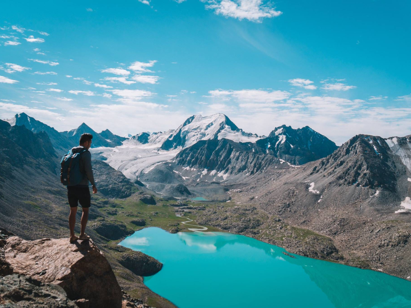
2) Ala Kul Trek (Kyrgyzstan)
Location: Karakol, Kyrgyzstan
Length: 2 – 4 days return
Highest Altitude: 11,600 feet
Distance: ~33 miles
Difficulty: Moderate
For such a small off-the-beaten-path country, Kyrgyzstan has a lot to offer for nature lovers with stunning canyons, pristine alpine lakes and plenty of hiking trails, all tucked away in the unexplored mountain range of Central Asia. One of that trail is the Ala Kul trail, a two to four-day hike that starts from the city of Karakol. This route will take you through one of the most stunning forests rich with vegetation and wildlife, then you get to camp under the stars at Ala Kul Lake. The best way to end this three-day hiking trip is to make your way down to Altyn Arashan, where you can soak in a nice natural hot spring.
The highlight of this trek though, is the Ala Kul Lake. You will have to hike along the side of a mountain passing the lake to the 11,600-foot-high pass and from there, you will be rewarded with a panoramic view of this alpine lake and the mountains behind it.

3) Grand Balcon Sud and Lac Blanc Trails (France)
Location: Chamonix, France
Length: 8 – 10 hours return
Highest Altitude: 7,716 feet
Distance: ~9.3 miles
Difficulty: Moderate but Long
The French Alps offer hikers plenty of opportunities to get lost in nature for a few hours with several trails for both single and multi-day hikers. One of my favorite single-day hikes is a combination of the Grand Balcon Sud trail and the Lac Blanc trail. The Grand Balcon Sud trail will take you up and along the side of the mountain overlooking the city of Chamonix and Mont Blanc. Throughout the trail, you will be rewarded with the beautiful jagged peaks on your right and colorful vegetation and wildlife on your left. If you are lucky, you might be able to witness the Chamois like I did when I was hiking up the Grand Balcon Sud trail in the early morning.
Towards the end of the Grand Balcon Sud trail, you can continue on the Lac Blanc trail to see the White Lake where the magic of this trail is. If the weather is calm enough when you arrive at the lake, you will be rewarded with a perfect reflection of the French Alps on the lake. It was quite a sight to behold.
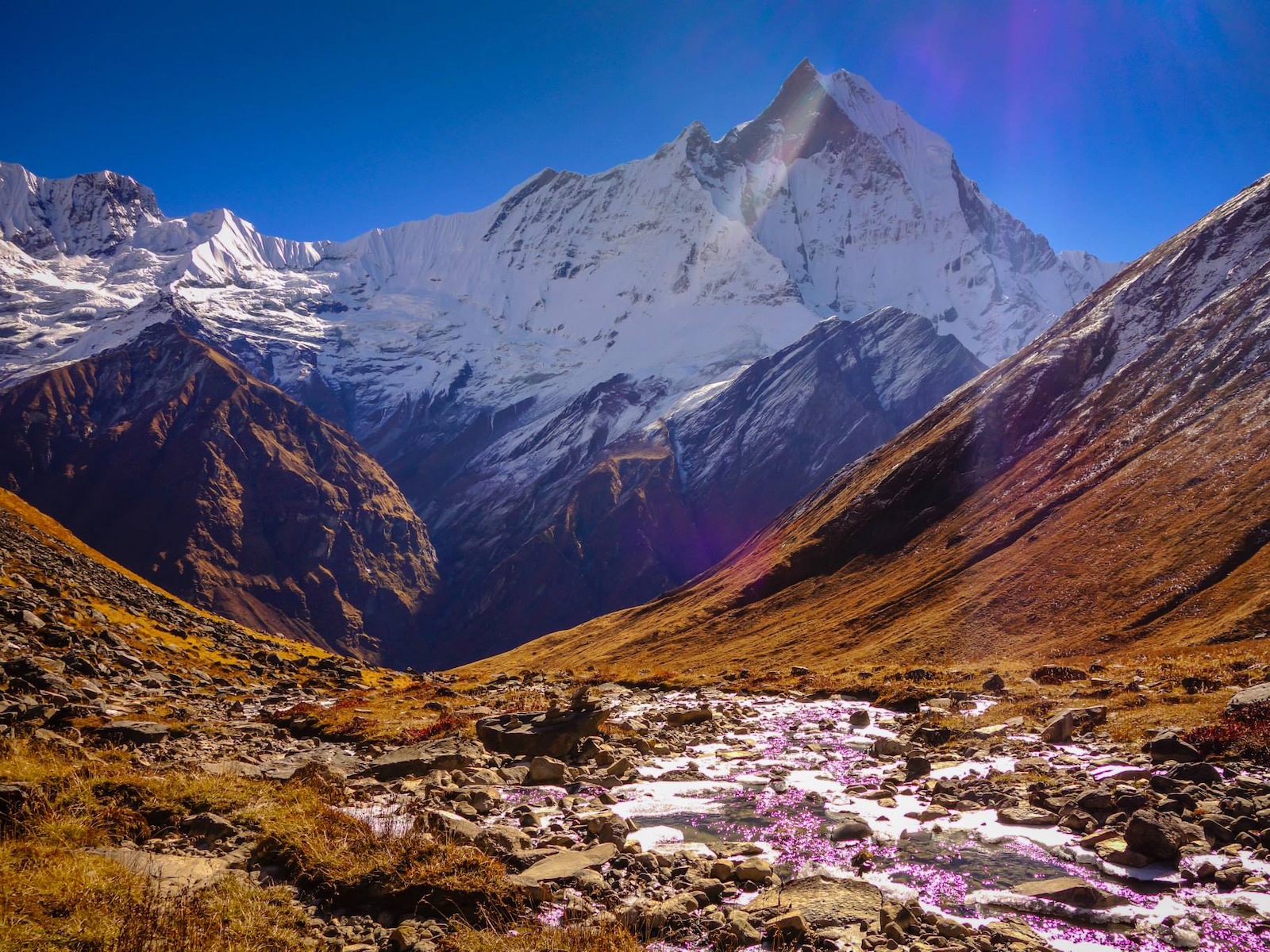
4) Santa Cruz Trek (Peru)
Location: Huaraz, Peru
Length: 3 – 4 days return
Highest Altitude: 15,583 feet
Distance: ~22.3 miles
Difficulty: Moderate
Huaraz in the north of Peru is one of my favorite places on Earth. I spent almost twoeeks alone in this city, exploring some of the best trails in the Cordillera Blanca mountain range. When people come to Peru, they always head for the south for the Inca trail and call it a day. What they don’t realize is that the true beauty of Peruvian mountains lies in the North, in Huaraz.
One of the treks I did was the Santa Cruz trek. I spent four days hiking in the solitude of the Cordillera Blanca mountain range through a beautiful canyon, stunning valleys and a pristine blue lake that serves as a great spot for camping. You will pass through one of the most beautiful scenery you will ever see in your life, sleep under the shadow of the towering Taulliraju mountain and be rewarded with a panoramic view of the mountain at its highest point of Punta Union Pass.
The experience of hiking this trail alone, carrying all my gear and food for four days, made it even more challenging and left me in awe for the rest of my trip in South America.
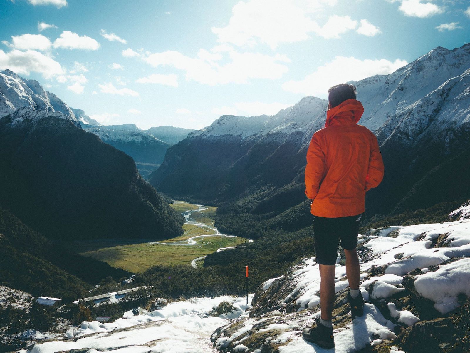
5) Routeburn Track (New Zealand)
Location: Te Anau, New Zealand
Length: 3 – 4 days return
Highest Altitude: 4,117 feet
Distance: ~20 miles
Difficulty: Easy
The Routeburn Track is one of New Zealand’s best great walks and for good reasons. The trail is located in the beautiful South Island starting near Te Anau and ends near Queenstown.
The trail will take you to the Key Summit on your first day, back down to sleep by the MacKenzie Lake, passing through the valley along the exposed Hollyford Face with expansive views over the Darran Mountains. Then it’s up to the Harris Saddle Shelter before coming down to Routeburn Falls Hut for your last night.
Your last day will be a casual walk down through the stunning beech forest, with a view of the Humboldt Mountains and ending at Routeburn Flats Hut. The Routeburn Track sure is an action-packed trail for you to do in New Zealand.
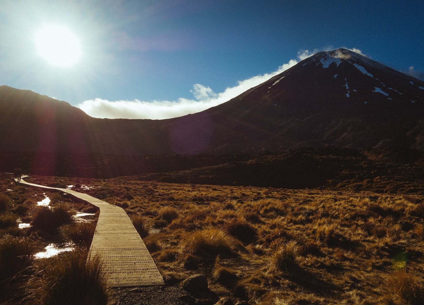
6) Tongariro Crossing (New Zealand)
Location: Lake Taupo, New Zealand
Length: 5 – 7 hrs return
Highest Altitude: 3,674 feet – 7,516 feet
Distance: ~ 12 miles
Difficulty: Easy to Moderate
Another great trail in New Zealand is the Tongariro Crossing trail, located in the North Island of the country near Lake Taupo. Like most trails in New Zealand, the Tongariro Crossing trail has a well-paced climb with casual walk up and steep parts all scattered throughout equally.
Starting from the Mangatepopo Valley, you will go through a series of gradual and steep climbs until you reach the saddle between Mount Tongariro and Mount Ngauruhoe. From here you can take a side trip like I did to go up Mount Ngauruhoe or to Mount Doom for Lord of the Rings fan. The trip will take two extra hours to do so but you will get a stunning view of the crossing in one whole swoop.
From the saddle, you will have to go through the South Crater before climbing again to the Red Crater. You will be able to see two lakes from up there, one in emerald green and the other in pristine blue. When you pass all the lakes, you will then have to zigzag your way past Ketetahi Shelter and down to the end of the trails.
The scenery is so diverse, it will have you thinking you were trekking for several days instead of five to seven hours.
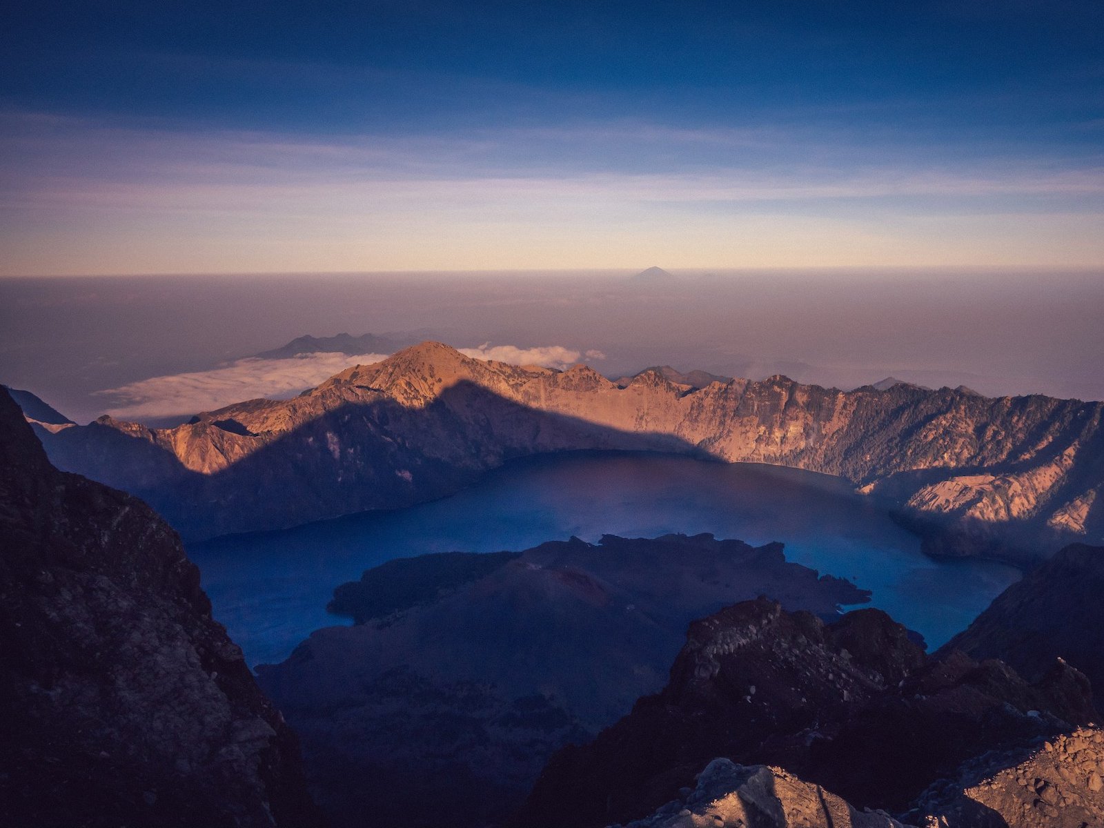
7) Mount Rinjani (Indonesia)
Location: Lombok, Indonesia
Length: 2 – 4 days return
Highest Altitude: 12,224 feet
Distance: ~ 21 miles
Difficulty: Moderate to Hard
Possibly one of the toughest hikes I have ever done, not because of the trail itself but due to the condition I was in while doing the hike. Hiking while suffering from good poisoning is not an ideal situation, to say the least.
That said, it is one of the best hikes you can do in Southeast Asia and you will be rewarded with a view of a volcano on an island inside a mountain on another island. Yes, that is indeed what you will see from the 12,224-foot-high summit of Mt Rinjani. The view is definitely better at sunrise when the shadow of the Mt Rinjani will be slowly receding from the volcano.
You will spend four days climbing up the ridge of the volcano, sleep under the stars, wake up early for a push to the summit and then down to the lake before climbing up again to another ridge and down, ending your trip. There is nothing more painful and rewarding at the same time than to climb up a volcano on a forever falling volcanic ash and then get to see a volcano on an island in a volcano on an island.
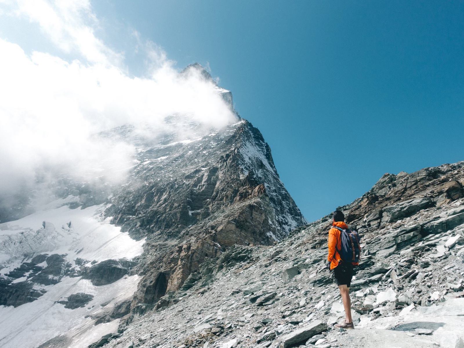
8) The Schwarzsee and Hornlihutte Trails (Switzerland)
Location: Zermatt, Switzerland
Length: 8 – 10 hrs return
Highest Altitude: 1,695 feet
Distance: ~15 miles
Difficulty: Moderate but Long
This is a combination of two trails that will get you the closest to the famous Matterhorn peak in Zermatt, Switzerland. The first part of the trail starts from the city of Zermatt and as you follow your way up the gondola line, you will arrive at Schwarzsee Lake where you can rest, have coffee at the mountain hut and continue your way up to the Hornlihutte. This is the exact location where one of the first climbers set off for their first ascent on the famous mountain in 1865.
You will go through a small traditional village before climbing up through the forest out into the exposed area at the Schwarzsee Lake. The landscape will become more rugged and rocky as you make your way up to the Hornlihutte mountain hut. If you decided to take an alternate route back via the Glacier trail, you will also be able to admire the mountain from the bottom of the glacier looking up. That was quite a sight to behold.
At the end of the Glacier trail, you will arrive at the Trockener Steg Lake where you can see the Matterhorn’s east face reflected off a body of water. There is no better way to see the Matterhorn than to hike this trail.

9) Laguna de los Tres trail (Argentina)
Location: El Chalten, Argentina
Length: 7 – 11 hrs return or 2 days
Highest Altitude: 3,871 feet
Distance: ~7.7 miles
Difficulty: Easy
Of course,Patagonia has to be on the list, but maybe this might not be the trail you are expecting. There are plenty of hiking opportunities in Chilean and Argentinian Patagonia, but the one I like the most is the Laguna de los Tres trail on the Argentinian side, starting from the quiet town of El Chalten.
This trail is my favorite because unlike the Torres del Paine and W Trek in Chile, the experience of hiking the trail is not ruined by the massive crowds that come with the peak season and has been plaguing those trails. Laguna de los Tres trail is a little less crowded, but offers you a similar experience as the trail will take you up close to the 3 famous landmarks of Patagonia, Mount Fitz Roy, Aguja Poincenot and Cerro Torre.
The trail is relatively easy compared to the other ones listed here with the majority of the trail pretty flat with two steep climbs at the beginning and at the end. You will pass through beautiful native woodland along the side of a mountain, coming across vast glaciers, frozen lakes and a few granite spires. As you continue on, you will pass through two camps where the last camp, Campamento Poincenot, is where you can stay overnight should you decide to extend the trip to two days. If you do so, I would recommend you go up to the Laguna de Los Tres as early as you can for the sunrise.
At the end of the trail, you will be rewarded with a stunning view of the impressive cobalt blue lake and icebergs of Laguna de Los Tres in the background. Over the icebergs, look up and stare at the looming spires of Fitzroy and its neighbors in awe and realize how fortunate you are to be able to see such beauty with your own eyes.

10) Laguna 69 (Peru)
Location: Huaraz, Peru
Length: 6 hrs return
Highest Altitude: 15,000 feet
Distance: ~7.4 miles
Difficulty: Moderate
Last but not the least, we are back in Huaraz again for another of my favorite trail, the Laguna 69 trail. This time, it only requires a day to complete but you will be rewarded with such a diverse scenery and plenty of photogenic mountains that you might forget you are doing a day hike. The trail begins slowly climbing through the valleys with several steep climbs along the way. Halfway through the trail, you will find a great spot by an alpine lake for a lunch stop before continuing on through a vast grassland. Push through the small granite path and head in to the heart of the mountain, where you will find a pristine blue glacier lake tucked away in between snowy mountains.
The moment you start to approach the lake, you will see a bright blue color, like nothing you have ever seen in nature. That’s when you will realize that you have finally reach Laguna 69. There is no mistaking it, the technicolor from the melted glacier is out of this world.
***
Nature has a way of rewarding you if you try hard enough and that is what I feel about hiking. The harder you work for it, the more rewarding it is. The mountain tests you, makes you lose your ego and you humbly appreciate both your own physical condition and the wild beauty of the world. I encourage you to go out there, get your hands dirty and start climbing.

/ ![]()
![]()
![]()
 Pete Rojwongsuriya is the founder of BucketListly.Blog, a place where he writes about his travel adventure and life stories he learned for the last 6 years on the road. He is also a travel filmmaker, photographer and a digital nomad, traveling from one country to another, making inspiring travel videos, taking stunning photos and telling a travel story of the world. His work in travel films has been featured on National Geographic, BBC, and Vimeo.
The post 10 Hiking Trails Around the World That Will Blow Your Mind appeared first on The Expeditioner Travel Site.
]]>The post In The Footsteps Of Twain (Up A Mountain In Switzerland) appeared first on The Expeditioner Travel Site.
]]>
Back in 1880, Mark Twain wrote that, “the Rigi-Kulm is an imposing Alpine mass, six thousand feet high, which stands by itself, and commands a mighty prospect of blue lakes, green valleys, and snowy mountains.” Whether Twain himself really was a tramp — as he refers to himself in A Tramp Abroad, his travel memoir from his travels through Germany and Italy — might be up for debate. But he certainly hit the mark with his descriptions of the Rigi-Kulm in Switzerland.
Each year, I come back to Lucerne, the Swiss town that Twain describes as “three-quarters of an hour distant” from the Rigi-Kulm. After an afternoon stroll along the cobblestone streets of the Lucerne harbor, I always visit the town’s notorious wooden bridge. Known in Swiss-German as the Kapellbrücke, the chapel bridge is a reconstruction of the original that burnt down tragically in the summer 1993. The Kapellbrücke is the landmark of Lucerne, and countless visitors flock to it each year.
Though I am normally not one to follow the well-beaten track, Lucerne’s Kapellbrücke continues to be one of my favorites. It is here that I reconnect every time with my birthplace. Peering out from underneath the wooden beams, I am enveloped by imposing mountains on each side. The slight waves on Lake Lucerne rock back and forth peacefully.
Last summer, I came across Twain’s A Tramp Abroad and was immediately enthralled by his humorous renderings. In particular, chapter 28, which involved his climbing Mt. Rigi, caught my eye. On countless occasions I had come across the name “Rigi.” It filled advertisements all over the Lucerne region. From skiing, to hiking, to biking, it was the paradise of outdoor sports.
I knew where it was and what it looked like. Many times had I seen the enormous flag of Switzerland that was draped on the mountainside over the village of Vitznau. It was a flag that had made national news numerous times. Thirty-one by thirty-one meters, it weighed a ton (700 kilograms to be exact). Hanging it had certainly been no easy job, and the Swiss were proud to show it off.
I, however, was embarrassed to admit that I had never been to the top of the flagged mountain. Considering myself a near-native of Lucerne, I felt I had a lot to catch up on. That very same summer I was set on following Twain up the Rigi. And while I was at it, I was going to take my entire family along as well. Twain led us the way: from Lucerne to Weggis, the village at the base of the Rigi. While the tramp tells us that he had arrived by boat, we decided to make it a car trip right along the waterside. It was a beautiful, winding road, the sun glimmering of the surface of the lake.
 In Weggis, the ascent to the Rigi-Kulm is, as Twain explains, “made by rail, or horseback, or on foot, as one may prefer.” Here we differed in preference from the tramp. While he elected to hike up, we opted for the small locomotive and said we would hike down instead. Waiting for the engine to start, I began reading aloud Twain’s tale to my parents. They, too, instantly enjoyed the humor and so, as the locomotive rolled, I continued reading.
Seeing us smile, fellow travelers began listening and laughing along. Twain’s tale became an unanticipated communal event, and when we reached the top, all of us were sure that we had done well in choosing the locomotive. The protracted suffering of Twain’s hike was alright to listen to, but no way did we need to experience it first-hand ourselves.
The locomotive reached its final stop, and though we had not completely finished reading Twain’s tale, we got off. For now, we would enjoy the landscape — the literature could be finished later.
Breathing in the crisp, fresh air, we hiked the few, final meters to the very top. Finally, I had reached the Rigi-Kulm cross that I had always marveled at from below. And in no way was I disappointed. The 360-view of the Alps left me speechless. Yes, I agreed in silence with Twain: the Rigi-Kulm certainly “commands a mighty prospect of blue lakes, green valleys, and snowy mountains.”
Still in complete awe, my family and I now made our descent. Again, we had made a better choice than Twain. While he had been tormented in the “dark and drizzly and cold,” we had chosen a stunning summer day. In fact, the sun shone down with such strength that we made a halt right across the locomotive station we had just gotten off at. Better buy my fair father a hat, I thought. With Twain’s suffering still imprinted on my mind, I didn’t want to risk any unnecessary suffering, be it a sunburn or something else.
 After the gift shop we strolled on, the first part of the downward trek still being rather even and not very steep. As we continued, cows grazed peacefully on each side. Soon, however, the trail become steeper, and we began to experience what Twain had surely suffered on the way up. The Rigi is a beautiful mountain — beautiful for those sitting on a mountain hut sipping a Rivella, the typical Swiss beverage with apple juice and sparkling water. For those who hike it, however, come prepared with energy. What on the locomotive had taken us perhaps half an hour, now took us four-and-a-half hours to descend by foot.
We arrived back in Weggis sweating, and starving. Luckily, the village is replete with little, family-run restaurants. In one of them, we opted for a carb-loaded Swiss classic: Rösti mit Spiegelei. Letting the yolk of the fried egg flow over the grated potatoes, we delved in hungrily. Reading aloud the rest of Twain could wait for another day.
By Isabel Eva Bohrer
The post In The Footsteps Of Twain (Up A Mountain In Switzerland) appeared first on The Expeditioner Travel Site.
]]>The post Why Every Skier Must Get To Europe appeared first on The Expeditioner Travel Site.
]]>
It’s no secret I choose skiing as my winter escape, so naturally I gravitate towards ski destinations this time of year.
Recently, Travel & Leisure put together a collection of 16 of the world’s scariest (ahem, gnarliest) ski slopes, convincing me that Europe may just be where it’s at.
In particular, France appears three different times on the list (check out this video of the Grand Couloir in Courchevel!), along with areas of Austria and Switzerland. That’s 31 percent of the entire article!
Even with Jackson, WY, Snowbird, UT, and Banff, Alberta (more to come on Banff later this week) making it, three of my favorites, I have to give a shout out to the Big Couloir at Big Sky, Montana (imagine a 45-degree, terrifyingly narrow chute) that ranks pretty high on the gnar scale.
So, maybe I’m a bit partial to my own backyard, but the point is, the terrain I’m seeing in Europe might easily convince me that it’s time for a ski pilgrimage. Wouldn’t you say?
The post Why Every Skier Must Get To Europe appeared first on The Expeditioner Travel Site.
]]>