The post La Carretera Austral: The Gravel Road To The End Of The World appeared first on The Expeditioner Travel Site.
]]>
Pan-American Transmissions: Part 12
“Pan-American Transmissions” is a travel series from Special Contributor Diego Cupolo as he travels south from Nicaragua to Argentina. He has few plans, a $10-a-day budget and one flute-playing gypsy companion. Check back as new dispatches are posted from the road.
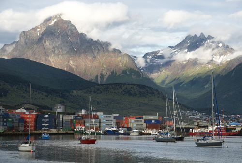
The overnight boat approached mainland Chile beneath the shadow of the Chaitén Volcano, a gaping caldera that erupted in 2008, burying the port below. Gray cinder still sat on the rooftops of abandoned houses along the coast and a thick sponge of ash floated in the water below us, forcing the captain to anchor offshore and wait until high tide in the early morning to dock safely.
Standing there, on the upper deck, I watched the sun rise over a jagged landscape so green it made the dismal ashtray of a town seem like a small footnote of human misfortune in a vast terrain of unspoiled natural beauty. This was Patagonia.
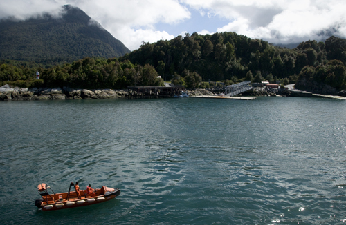
Around me, a strange mix of passengers waited anxiously to disembark. They were Czech film crews, Danish Hell’s Angels, Japanese mountaineers and cross-continental cyclists of all nationalities. We boarded in Chiloé and together we sailed through the night, bounded by one all-consuming, unreasonable need to reach the end of the world: Ushuaia.
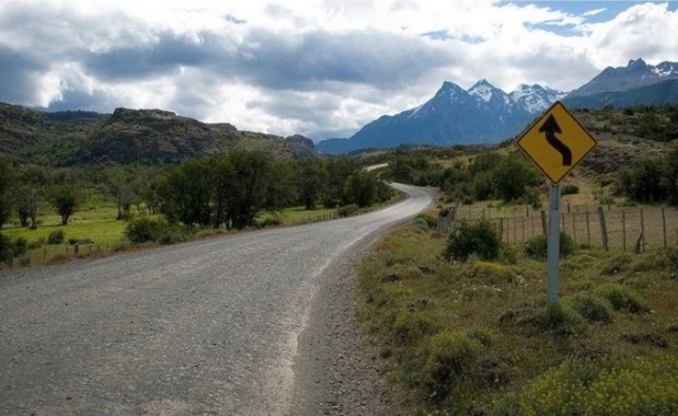
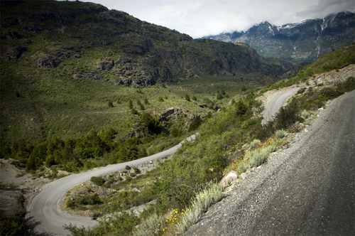
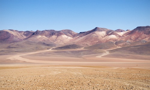
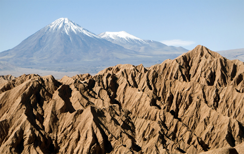
To reach this city at the southern tip of South America, one can choose between two paved Argentinian routes or Chile’s Carretera Austral, a 770-mile (1,240 km) stretch of mostly gravel mountain passages through the most vibrant and least inhabited regions of Patagonia. Having been completed in the early 1980’s, the road gave access to long isolated areas and locals like to call it the only good thing former dictator Pinochet ever did.
When our boat finally docked that morning in Chaitén, the fervent passengers rushed out down the highway like horses at the track. I, too, was fervent, but hungry, as well. Inside the town bakery, I gnawed two-day-old bread as I spoke with the lady behind the cash register, trying to get a sense for the route ahead. Traffic would be less than sparse, buses were few and all forms of transportation were severely expensive.
At that moment, I remembered a song by Joan Manuel Serrat. A friend had played it for me before I left Buenos Aires and he highlighted one verse in particular: “Caminante son tus huellas el camino y nada más; Caminante no hay camino, se hace camino al andar,” which roughly translated into, “Walker your footsteps are the path and nothing more; Walker there is no path, the path is made by walking.
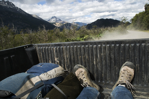
Standing in that bakery, stale terrible bread in hand, I decided to go down the Carretera Austral on foot. I’d accept the occasional lift — when there was one — but I would go on to spend the majority of the next month marching towards Ushuaia, the end of the road, a place I’d been trying to find ever since I got off training wheels.
This was it. Two legs, a 25-kilo backpack, a bag of oatmeal and a sack of powdered milk. Sixteen months after landing in Nicaragua, this grand Pan-American voyage was coming to a close.
Se Hace Camino al Andar: Down the Futaleufú to Queulat National Park
My instincts were right, but the direction was wrong. After the first day on the road I woke up in Futaleufú, a town near the Argentinian border, about 50 miles off course. I had spent the prior day in Parque Pumalín, one of many large conservation areas in southern Chile owned by North Face co-founder Douglas Tompkins, prompting suspicious locals to accuse him of creating some kind of secret Zionist state.
When I popped out of the bushes I caught a ride to with an Argentinean hippie couple heading to Futaleufú. I asked if the town was south on Carretera Austral and they said yes, but that was a lie. Stranded and with few options, I started walking back towards the highway. About four hours later, a truck hauling two rafts stopped and gave me a lift. The driver said he was starting a new whitewater rafting company and was about to shoot a promotional video.
“We need one more guy in the raft,” he said. “We’ll give you all the gear and drop you off downriver near the Carretera Austral free of charge. It’s your lucky day. Do you want to join us?”
I didn’t know it, but we were just next to the Futaleufú River, a world-renowned water sports destination with Class 5 rapids. I had only been whitewater rafting once before in Chattanooga, Tennessee, but agreed to go along because, hell, who wouldn’t? Suited up, with a yellow paddle in hand, I climbed into the raft with three guys that had Go Pro cameras attached to their helmets.
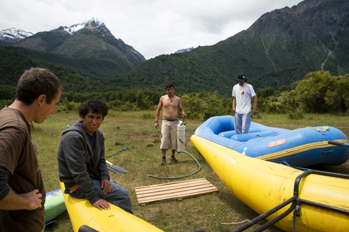
Together we floated down the bright turquoise river towards rapids with names like “The Terminator” and “The Himalayas.” As the raft approached the first set of rapids, a canyon of roaring white foam broken only by massive boulders, the guy in the back began shouting instructions. “Right side paddle! Stop! Left side paddle! Right paddle backwards! Everyone! Weight on the right!” Failing to follow commands meant flipping over.
For the next two hours I didn’t see much more than my paddle and white foam. At some points, the front end of the raft would go airborne and my paddle wasn’t long enough to reach the water below. At other points, violent waves crashed over the nose, blinding us for one second too long, leaving the raft at the mercy of the next wave. People do this for fun. Paddle or die.
By the end we were all howling like wolves. The final rapids were Class 4 and, well, I could actually enjoy those because I could see what lay ahead. We ran the whole course of the Futaleufú River — or “Big River” in the native Mapuche language — and as promised, the guys let me off near the Carretera Austral. Just like that I had gotten back on course. Completely drenched, freezing cold and still shaking with adrenaline, but back on course.

That night I camped on the side of the road with a retired baby boomer couple from Santiago that had picked me up in their Volkswagen RV. We drank Crown Royal and they showed me all the Apps of their new Samsung tablet. In the morning, the two dropped me off in Queulat National Park, where mountaintop glacier fields melt into a thousand waterfalls above misty Pacific rain forests, and an entire new day in Patagonia began to unfold.
I stashed my bag behind a fallen tree and hiked up the Bosque Encantado trail with a group of Israeli backpackers. Climbing in the light fog, we worked our way through a maze of green moss that connected every branch, stone and leaf, making the forest seem more like a single living organism than individual trees or plants.
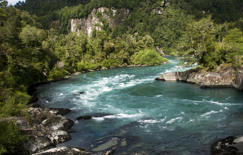
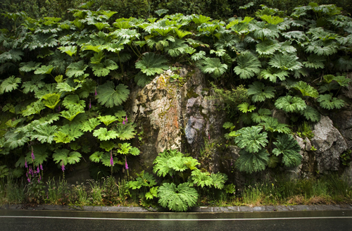
After lunch it started to rain, as it often does along the Pacific coast. I grabbed my bag and continued south on the Carretera Austral. Rain soon turned to downpour, but I kept walking, using a big nalca leaf as an umbrella until I reached Piedra del Gato, a small gorge about 13 miles down the highway.
There, while I stood on the side of the road, looking down at the another set of turquoise river rapids, a local pulled over. His name was Erwin and he was a fisherman. He knew every island, mountain and river in southern Chile. From time to time, he worked as a helicopter guide for rich tourists looking to go “deep” into the mountains. Erwin laughed at me, standing in the rain with my nalca leaf umbrella and asked if I knew how to eat nalca.
“You can eat this?” I asked.
“Claro. Of course, but only the stem,” he said before jumping out of his old pick-up truck and finding a few plants.
Erwin said the best plants for consumption were young and had flexible stems. The taste peaks just before if the leaf opens. Erwin took a stem, shaved off the red spikes with a knife and cut me a piece. It tasted like celery, only more juicy and more bitter. Not bad.
“These grow in every rainy region of Patagonia. You can live on them,” he said. “You know, one time a 70-year-old man got lost in these woods and rescue squads couldn’t find him. About a month went by before they called off the search, assuming he was dead, but two months after that, the guy came out of the forest alive and well, having survived on a diet of nalca stems. He was 70 years old.”
“They’re also good for digestion,” he added as he took a bite. “If you have a stomach ache, they’ll probably make it go away.”
Erwin dropped me off outside Coyhaique where I dried my clothes over a campfire for the night. His advice on nalca plants and forest survival would prove more than valuable for the rest of the trip and I kept his number in case I ever have enough money for a Patagonian helicopter tour.
Son Tus Huellas el Camino: Coyhaique and Lago General Carrera
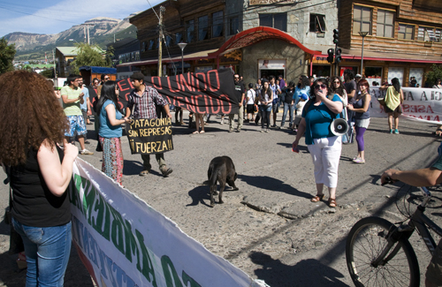
The apocalypse came and went and 2013 arrived as I reached Coyhaique, a city of 50,000 inhabitants. Civilization, at last. Internet cafes, organic quinoa cookies and teenage goth punks with lip piercings. I stayed with a local couchsurfer for a week as I conducted interviews and attended protests against HidroAysén, an $11 billion hydroelectric project that aims to build five dams in two of Patagonia’s largest rivers. One of several divisive issues in Chile at the moment.
In the meantime, I also visited the autonomous communities rising along Coyhaique’s city limits. House prices in Patagonia can be astronomical, so a growing number of young people are buying small plots of land and building their own homes from scratch. The resulting off-the-grid villages sprouting up throughout southern Chile make for a compelling social experiment.
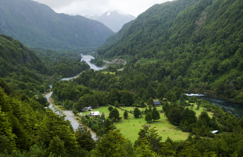
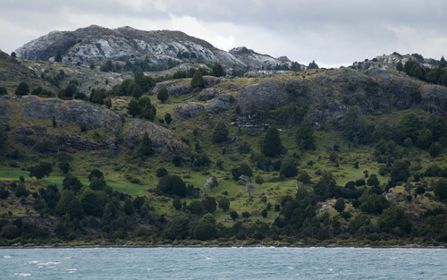
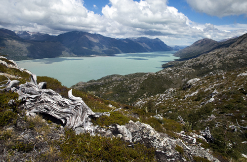
The slow country life and open-minded people made Coyhaique an easy place to stay for a while, but I had to keep moving and continued south as soon as I finished my research. Two days and three rides later, I passed through Reserva Nacional Cerro Castillo — the poor man’s Torres del Paine — and reached Lago General Carrera, Chile’s largest and probably most scenic lake.
Here, the Carretera Austral runs through some of the most beautiful landscapes in the world. No amount of open-mouth staring can suffice. I set up camp along the lakeshore in Puerto Rio Tranquilo and watched the pink cliffs melt slowly into cyan waters over and over again. A natural hypnosis.
The next morning came with a mess of rain. This was to become a recurring theme throughout the trip. In southern Chile, coastal areas are especially prone to showers while interior regions enjoy much drier weather. This is the case with Chile Chico, a town known for its pleasant Mediterranean micro-climate near the Argentinian border.
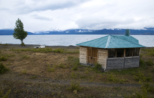
Hoping to get out of the rain, I made my way around the lake towards Chile Chico and arrived in Puerto Guadal, a small village on the verge of being abandoned. The streets were empty, all the windows were shut and the stores were closed. I tried knocking at the door of the grocery store, but no one answered.
Halfway to starving, I found two rotten apples in a trash pile behind the store and was considering them as a meal when a middle-aged woman appeared on the street. She was round, disheveled and walked in zig-zags. The first sign of life in the village. I approached her to ask about the store.
“Buenos dias, discuple,” I said to be polite. “Do you know if the grocery store is open at this time?”
She looked at me like snakes were coming out of my mouth. Her lips pressed shut and her eyes widened with manic confusion. She seemed disturbed by the sight of my face and kept watching me as she walked away without saying a word. As I write this, I still wonder what she saw during that long, strange moment. That kind of insanity is contagious and must thrive in these small mountain villages.
No one else passed for a while and then the store owner finally arrived. I entered bought my Patagonian staple food: bread and tubed cream cheese (the cheapest food in a region that produces little aside from meat). I ate as the rain became heavy again and then went on my way down Route 265 towards Chile Chico, to the dry weather everyone talked about.
I never made it. The showers made a stream of the gravel road and about four cars passed in the six hours I had been walking. The sun was setting and I was soaked again. Without a dry place to sleep, I took refuge in the barbecue hut of an empty vacation house, a structure locally known as a quincho. The door was unlocked and there was a stack of wood next to the grill so, well, I made a fire and hung my clothes to dry.
Adventure means going outside your comfort zone and considering all the wet, miserable places I could’ve ended up, the shelter of this quincho wasn’t bad at all.
The rain stopped the following morning and I woke up to a clear view of Lago General Carrera with snow-covered mountains on the opposite shore. You could say it was a well-placed vacation home. I collected driftwood to replace what I had used through the night, packed up, and once again made my way back to the Carretera Austral, abandoning any hopes of reaching Chile Chico.
Caminante no Hay Camino: Cochrane, Caleta Tortel and Villa O’Higgins
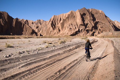
Through the final and least transited section of the highway, I spent many nights camping along riverbanks and many days walking non-stop, fueled by an abundance of nalca plants. Thanks Erwin. Though I was alone on foot, I had daily encounters with a trio of Chilean cyclists that were biking the entire road. We traveled at about the same pace and we often shared lunches, travel stories and all-important weather reports.
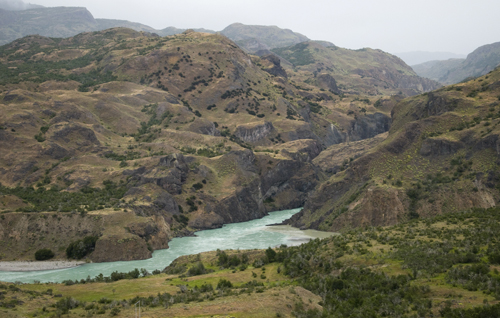
Locals say “those who hurry in Patagonia lose time,” and we made sure to go as slow as possible through the open country. After the night in the barbecue hut, I walked to Lago Bertrand and then south along the Rio Baker, one of the two rivers currently threatened by hydroelectric dams.
When I reached Cochrane, a town of 3,000, I stayed with another couchsurfer as I finished up a few more interviews on the HidroAysén project. My host was nice. He looked like Trent Reznor and made big, vegetarian meals, but he had just broken up with his long-time girlfriend and there were a few holes in his bedroom door at about fist level so I made sure to tread lightly and stay briefly.
The further south I went, the more “tavanos”, or giant horse flies, there were. The bastards like to bite and every time you kill one, ten more show up to fly around your head. Still, the scenery was incredible. I look back at my photos and, though I was there, I still cannot believe these places exist.
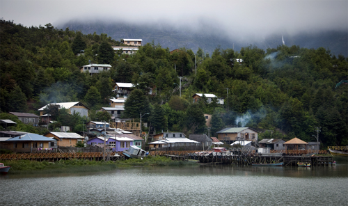
A good example was Caleta Tortel. The Chilean cyclist told me to visit the small port town, wedged between fjords on the Pacific shore, so I took a detour off the Carretera Austral towards the coast on a road that was completed only in 2003. On arrival, a maze of wooden plank stairways and walkways led through a strange settlement of stilt houses with smoking chimneys and tired sailors smoking pipes.
Among the seafarers was an Alaskan who sailed around the world three times in a 15-meter boat. He was old, didn’t smile much and had just come around Cape Horn on a straight shot from Norway. He said he once spent 78 days out on the sea, alone, while crossing the Pacific. His secret: an on board dutch oven for baking bread.
Aside from the sailors, Caleta Tortel was a little dull and overpriced, a consequence of heavy cruise ship tourism. I got back on the Carretera Austral, crossed the Rio Bravo on a free ferry and got picked up by a French couple on the other side. Together we drove through the rugged mountain valleys that make up the last 90 km of the highway. Along the way, we spotted a pair of local fishermen in the Rio Mayer and bought two mid-sized trouts for USD$3.00.
That night, the three of us cooked fish with rice over a campfire on the lakeshore and, well, life was good. We shared two bottles of wine and I learned they were Calculus majors visiting Chile for an international mathematics conference. You never know who you’ll find on the road.
In the morning we arrived at Villa O’ Higgins, the somber end of the Carreterra Austral. With just 500 residents, the village acts mainly as a backdoor entrance to Argentina. An expensive ferry, (about USD$80.00) provides sporadic transit across Lago O’ Higgins to Candelario Mancilla where travelers can hike about 20 miles over a several mountains to reach the nearest road in Argentina. Except for two military border checkpoints, there’s nothing out there. I pitched my tent and waited for the next ferry, collecting necessary provisions in the meantime.
Y Nada Más: Crossing to Argentina, Reaching Ushuaia
The journey down the Carretera Austral began and ended with a boat ride. Because of the Southern Chile’s rugged mountain terrain, there are no overland routes from Villa O’Higgins to Tierra del Fuego, forcing both travelers and locals to cross over to Argentina in order reach Chile’s southern tail.
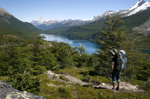
On a sunny Friday morning, I rode the ferry across Lago O’Higgins and shared one last lunch with the Chilean cyclists before setting off for Argentina. With 25 kilos of crap on my back, following this tiny trail up and down mountain valleys would make for one of the hardest hikes in my life.
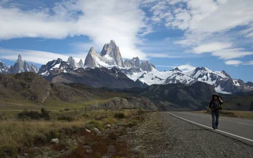
For two glorious days I walked in a silence broken only by the occasional crack of a mountaintop glacier. A sharp echo would bounce off the valley walls, and I’d look up just in time to see an avalanche of ice pour into the river below. In front of me, Mount Fitz Roy jutted into the sky like massive canine tooth of bedrock, and this handsome mountain served as a beacon for El Chaltén, the closest town in Argentina.
I camped on the shore of Lago del Desierto and hiked through the forest until I reached some kind of vacation resort on the opposite shore. It was packed with screaming children getting scorned by their screaming parents. Civilization once more. After that it was easy. All the Patagonian mega-attractions — El Chaltén, El Cafate, Torres del Paine National Park — were connected by wide, smooth highways, and as a result, they were filled with tourists and extremely high prices.
Of course, the scenery was amazing, but not much different from the landscapes along the Carretera Austral. The same was true for Ushuaia. Retired Swiss tourists filled the streets, paying top dollar for everything, from bread to bunk beds, all to see about the same sights anyone can enjoy in Chile, free of charge.
It’s sad when you realize your final destination is nothing more than a tourist trap, but, excuse the cliche, it was the journey that mattered. Few destinations in world can compare with the untamed wilderness in Southern Chile, and there’s no better way to experience it than by walking, biking or driving down the Carretera Austral. The key is to stop thinking, saving, planning and dreaming, and just go. The rest will work out. “Se hace camino al andar” can also mean “The path is made by going forward.”
To commemorate the end of the journey I shaved off my mountain beard in Ushuaia and threw it into the Beagle Channel, a passage named after the ship Charles Darwin boarded at this very same port to reach the Galapagos Islands. Without the funds to stay in town for more than two nights, I caught a lift back to Buenos Aires with a Brazilian truck driver and that was it. I flew back to Montreal to be with Ania again.
Looking back, Moving forward
Nicaragua to Tierra del Fuego. You’re supposed to have big, thoughtful observations after long expeditions into foreign lands. The world becomes smaller. Vague terms like “poverty” and “globalization” gain meaning. You change. The people around you change. Yet, still, it takes time to digest a year and half on the road.
For now, I’ll just say that throughout those long, peaceful days spent walking along the Carretera Austral, I’d look at the mountains, the rivers and the lakes and they seemed so separate from humanity, so indifferent to our presence. Through every war, dictatorship and mistake we ever made, those valleys remained the same. Untouched. I wanted to stay there for the rest of my life.
Not long after, I realized this observation was wrong and not simply because I was walking on a man-made highway. When I arrived in Tierra del Fuego, locals were in shock over the recent heat waves were hitting the Antarctic island. They never experienced such balmy weather patterns and the uncomfortable sweat on their brows came with tinge of fear.
With that thought, I rode back through the dry Argentinian plains and returned to North America. Traveling and having fun is great, but we — all seven billion of us — have a lot of work to do if we want to continue enjoying places like Patagonia and, in a broader sense, our time together on this tiny planet.
Thanks for reading.
By Diego Cupolo
Read all of the other Pan-American Transmissions entries here.

About the Author
 Diego Cupolo is a freelance photojournalist currently on the road to Tierra del Fuego. Most recently he served as Associate Editor for BushwickBK.com, an online newspaper in Brooklyn, and his work has appeared in The New Yorker, The Atlantic, The Star-Ledger, The Australian Times, Discover Magazine and many other publications. View more of his work at DiegoCupolo.com.
The post La Carretera Austral: The Gravel Road To The End Of The World appeared first on The Expeditioner Travel Site.
]]>The post The Driest Place on Earth: From Bolivia’s Salt Flats To Chile’s Atacama Desert appeared first on The Expeditioner Travel Site.
]]>
Pan-American Transmissions: Part 11
“Pan-American Transmissions” is a travel series from Special Contributor Diego Cupolo as he travels south from Nicaragua to Argentina. He has few plans, a $10-a-day budget and one flute-playing gypsy companion. Check back as new dispatches are posted from the road.
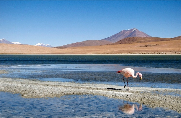
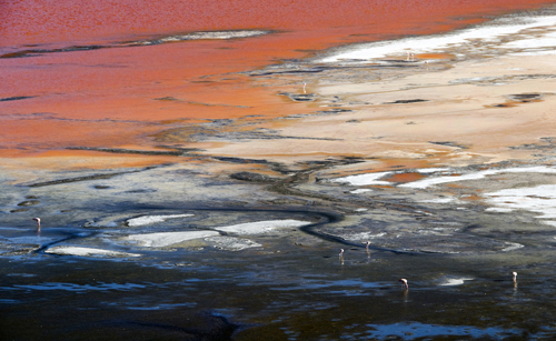
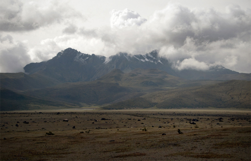
Pink flamingos wade through blood-red lagoons on a seemingly endless plateau of snow-covered volcanoes, vast salt deposits and leftovers from ancient lakes that dried long before the first human ever stepped foot on the continent. Surrounded by this panoramic gallery of Dalí paintings, I peel off the cracking skin from my knuckles and wonder, “How the hell did we get here?”
After many years spent living in crammed city apartments, Ania and I needed space — a lot of space — so we headed to the southwest section Bolivia where the Andean high plains, known as the Altiplano, meet Chile’s arid Atacama desert and spill down into the Pacific Ocean. With its rare geologic formations and an average rainfall of just one millimeter per year, the region is one of the driest, strangest places on Earth, leading many scientists to say it looks more like Mars than any part of the blue planet we call home.
Ania and I arrived eager to get lost in other-worldly destinations like the massive salt flats of the Salar de Uyuni and jagged canyons that make up the Valle de la Luna. As we learned in the Amazon, Bolivia is a nation of extremes and the most isolated places are only accessible through tours, which is lame, but what else can a cash-strapped traveler do?
We hired a driver for a three-day desert tour to the Chilean border and when we crossed over, Ania and I took exploration into our own hands by renting mountain bikes. Both experiences had their pros and cons, but in the end, the heavy Atacama sun pounded our shoulders, the dry desert air made our skin rough like sand paper, and it was all worth it when we saw the barren desertscape turn into a kaleidoscope of purple every sunset and sunrise.
The Salar de Uyuni
Ania and I watched countless herds of llamas pass the bus window and ate even more quinoa-potato soups before we would reach the town of Uyuni and receive one crucial piece of advice: “Try to hire a tour guide that won’t drink and drive.”
As we soon found out, Salar de Uyuni tour agencies vary greatly in quality and the amount you pay is not always an indicator of the experience you’ll get. Breakdowns, flat tires, bad food, alcohol-induced accidents: a lot can go wrong on a multi-day off-road tour through the open desert.
For better or worse, we chose the Estrella del Sur agency to take us on a three-day tour through the Salar de Uyuni and Eduardo Avaroa Andean Fauna National Reserve before dropping us off at the Chilean border. Total price: $700 Bolivianos, or about USD$100 with food, accommodation and park fees included.
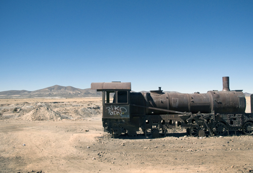
We began early in the frigid morning air. The driver pulled up in a Toyato Landcruiser. His name was Fredo and he looked sober, which was good, so we loaded the car with four Irish medical students that would make up our tour group for the next three days. Our first stop was an enormous abandoned train graveyard outside the town, an orgasm for photographers and rust enthusiasts, but Fredo told us we had 10 minutes to explore the site so we could rush to the second stop, a gift shop that sold little llamas made from salt, where we would spend half an hour.
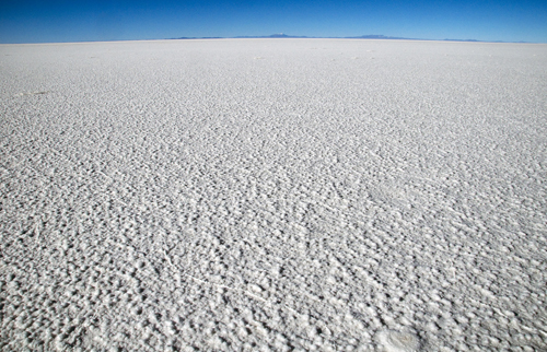
With souvenirs tightly secured in the back, we entered the Salar de Uyuni, the largest salt flat in the world. A place is so large and so flat that Earth observation satellites use its surface to calibrate their altitude meters and global positioning systems.
According to fossil records, the Salar was part of prehistoric Lake Minchin more than 30,000 years ago. Standing at 11,995 feet above sea level, Lake Minchin would’ve competed with Lake Titicaca for highest lake in the world, but it dried up thousands of years ago, leaving behind the flat concentration of salt we see today.
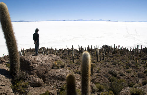
As we drove through the blinding white leftovers of history, Fredo explained the volcanoes around us used to be islands when the lake was still around. We took a chance to stop at Isla Incahuasi, one of the small “islands” in the middle of the Salar, and got out for a short hike on the rocky outcrop. Here visitors can walk over old corrals that once housed prehistoric lake creatures and stand among giant cacti that grow one meter per century. Not bad.
When we returned to the car, Fredo cooked up a few Alpaca steaks and we ate lunch as he boasted about how Alpaca meat was free of cholesterol. Not bad at all. The tour was looking good at that point.
Then the Irish students blasted Lady Gaga music in our car as Fredo rushed us out of the Salar. He said we needed to reach the hostel before sunset, which was confusing since the tour agency told us the highlight of their tour was watching the sunset from within the Salar. Basically, it was main reason to visit the salt flats and we’d be missing it. A tragic realization, but perhaps not as tragic as finding out people over the age of 20 are willfully listening to Lady Gaga.
Without stopping another time on the salt flat, we arrived at the hostel by 4 p.m. and were told dinner would be served in three hours so we could sit and have tea or something. Ania and I took the chance to run away — far, far away — from the tour group and went back into the Salar on foot.
Though we didn’t get far — the place is 4,000 square miles — we did finally get some quality time with the barren land, the silence and the nothingness to contemplate very serious questions. Local legend says mankind was born from Lake Titicaca, but Ania and I figured it was more likely that our ancestors crawled out of Lake Minchin after the water dried up.
It all made perfect sense as the sun set and our shadows grew long while the sky turned into bands of orange, purple and yellow, each color reflecting off the white surface of the Salar.
“I wouldn’t mind dying here,” I thought to myself. And then it got cold and we went back to the hotel for dinner.
The Eduardo Abaroa Andean Fauna National Reserve
Early the next morning, Ania and I made another short trip into the Salar to watch the sun rise and have one more holy experience before breakfast. We came back frozen stiff, ate and then waited for Fredo, who showed up 30 minutes late only to take us on a short ride to the nearest store, where he would sit and talk with the owner for another 45 minutes. All the other tour groups were way ahead of us.
When he was ready, we drove quickly through a region of multi-colored lagoons with Andean flamingos wading through volcanic hot tubs and stopped briefly to take in the surreal imagery as Fredo repeated, “Come on, don’t go far from the car, we don’t have time.” I wanted to punch him in the face.
The rest of the tour pretty much went on like this. Inside the Eduardo Abaroa Andean Fauna National Reserve, we drove through some of the most beautiful scenery in the world to the soundtrack of Lady Gaga and never seemed to have enough time. Volcanos, geysers, boiling mud pits, petrified lava fields, peculiar rock formations, splashes of paint on martian landscapes — the sights were truly amazing, but less enjoyable when broken down into standardized drills: Drive, step out, take a picture, drive.
Maybe this is what the tour is supposed to be, but the other tour groups didn’t seem so rushed. Not to mention our Irish car mates’ non-stop celebrity gossiping. Oof. Maybe it was just bad luck.
The last day of the tour, I met a Chilean photographer who shared my grievances and he gave me some good advice: Take the Salar tour with a Chilean company.
This was his third time through the region (fist time with a Bolivian company) and he said Chilean agencies cost a little more, but they provide a much better tour than Uyuni-based companies. It’s the same three-day trip, only backwards so you finish at the Salar de Uyuni.
“Basically,” he said. “Chilean agencies are more likely to deliver the experience they advertise.”
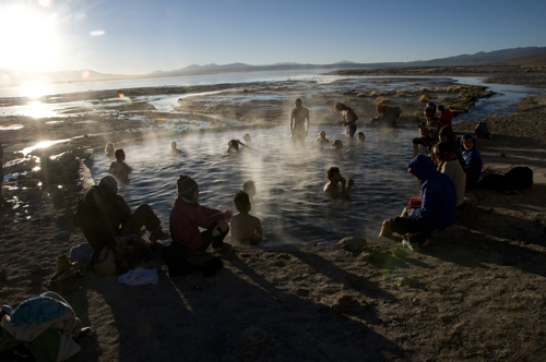
Still, the photographer was explaining all this as we sat in a natural hot spring, watching the sun rise through the steam of a distant volcano. The small inconveniences of the trip were worth the the scenery. It could’ve been much worse. We simply had high expectations for the Salar tour.
That said, Ania and I got dropped off at a lonely bus stop they called the Chilean border, and vowed never to take a tour again.
Into the Atacama Desert
An hour after descending 2,000 meters (about 1.25 miles) from the Altiplano, Ania and I reached the Chilean customs office in San Pedro de Atacama where security guards took our apples, calling them a threat to national security even though they were labeled with “Grown in Chile” stickers.
Rules, regulations, working toilets and organic flax seed granola bars — we crossed an imaginary line in the desert and everything changed. After four months in the Andes, Ania and I came down from the indigenous Altiplano and fell back into what most people would would call “Modern Western Society.”
Without hesitation, we took this opportunity to rent mountain bikes. It was recommended by every traveler we crossed and costed about USD$10 for a day, so what the hell? With a map in hand, we set out for the Atacama desert on our own.
We rode through shallow rivers to a red quartz canyon they call the “Throat of the Devil.” We circled spiraling rock towers. We climbed whatever peak looked interesting and rested in whichever shade seemed inviting. It was a much easier to enjoy the landscape without a guide telling us what to do.
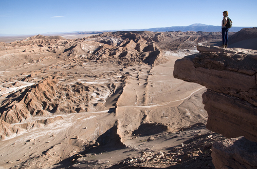
The main drawback to this approach is that we got lost out there. Far away objects can appear closer than they really are in wide open spaces. While trying to find the famed Valle de la Luna, we pedaled about two hours in the wrong direction. Still, in the confusion, we found a few cliffs with unforgettable views over the hypnotizing valley and enjoyed its lunar surface from above.
Sure, we never made it inside Valle de la Luna, but it didn’t matter. We were more than satisfied. This was adventure. This was the reason we had come to the Atacama, a place where the sun burns, the shade freezes and the dry air makes alligator scales out of your skin. Mars climate. Peace at last.
Hitchhiking South and Beyond
There’s a lot more to do in San Pedro de Atacama, but we couldn’t afford it. More salt flats, more hot springs and more geysers. It’s worth a longer visit. Instead, Ania had a plane to catch. After 10 months, our trip together was coming to an end.
With too many stories to tell, we hitchhiked to the paradise port city of Valparaiso, then Santiago, and then all the way over to Buenos Aires where we would slam on the brakes and fly through the windshield. Ania landed in plane seat back to Montreal, which was sad, and I landed in an office chair where I would work for the next five months, which was only slightly less sad.
Without a doubt, we would be reunited again, but not before I finished this long journey and reached the end of the road in Tierra del Fuego.
By Diego Cupolo
Coming up next, the final installment of Pan-American Transmissions: La Carretera Austral: On a Gravel Road to the End of the World.
Read all of the other Pan-American Transmissions entries here.
About the Author
Diego Cupolo is a freelance photojournalist currently on the road to Tierra del Fuego. Most recently he served as Associate Editor for BushwickBK.com, an online newspaper in Brooklyn, and his work has appeared in The New Yorker, The Atlantic, The Star-Ledger, The Australian Times, Discover Magazine and many other publications. View more of his work at DiegoCupolo.com.
The post The Driest Place on Earth: From Bolivia’s Salt Flats To Chile’s Atacama Desert appeared first on The Expeditioner Travel Site.
]]>The post Into The Amazon: Bolivia’s Gateway To The Jungle appeared first on The Expeditioner Travel Site.
]]>
Pan-American Transmissions: Part 10
“Pan-American Transmissions” is a travel series from Special Contributor Diego Cupolo as he travels south from Nicaragua to Argentina. He has few plans, a $10-a-day budget and one flute-playing gypsy companion. Check back as new dispatches are posted from the road.
“The ‘call o’ the wild’ is in the blood of many of us and finds its safety valve in adventure.”
Percy Harrison Fawcett’s words bounced in our thoughts as we rumbled down the Andes into Bolivia’s Amazon basin. Ania and I had just finished reading David Grann’s The Lost City of Z, a tale of Fawcett’s wild expeditions as he hacked his way through the jungle, eventually vanishing in search of what many called “El Dorado,” the forgotten kingdom of gold.
Stories of wrestling matches with anacondas, flesh-eating maggots and hostile indigenous tribes filled our imaginations while our bus turned and weaved through 20 hours of rocky, muddy, terrible, tombstone-ridden roads on the way to Rurrenabaque, Bolivia’s gateway to the Amazon. “Rurre,” as locals call it, is known for being one of the easiest, most cost-effective jumping boards for anyone looking to dive into Fawcett’s old stomping grounds.
You could say we were excited. In this long voyage through Latin America, visiting the Amazon was never part of the plan. Ania and I figured it was out of our $10-a-day budget, but that was before a company from Dubai bought a batch of my photos. We immediately threw down our reservations, stocked up on insect repellent and chose to use the winnings on a small expedition into the world’s largest rainforest.

Of course, when we arrived, the reality wasn’t quite like we imagined. Like many Amazonian settlements, Rurre isn’t the exotic riverside village it used to be. It’s been thoroughly saturated with tour companies. Regardless, the town remains a necessary stop for jungle adventurers, because how the hell else are you going to make it in and out of the Amazon without a decent guide?
Here’s the run down: a three-day tour costs about USD$75-$100 per person, but be aware, Rurre has one general rule: All tour companies lie. The only thing you can do is find the agency that lies the least. That said, the two main tour options are: a) a relaxed, wildlife-sightseeing three-day boat tour in the pampas (wetlands) where visitors stay in riverside cabañas, or b) an adventurous, machete-hacking three-day selva (jungle) tour in the nearby Madidi National Park where visitors hike through the rain forest, build their own shelters and camp with jaguars.
Ania and I splurged and did both. The pampas tour turned out to be a bit too laid back for our taste, most of the activities involved sitting and eating so I won’t talk about that here. On the other hand, the jungle tour left us soaking wet, bite-ridden and completely satisfied. With all the ways to die in the Amazon, just one day inside this venomous jungle is enough to spark a new appreciation for life and, at the same time, gain a deeper respect for old-fashioned explorers like Fawcett, who went missing not far from this region a little less than 100 years ago.

Day One: Meet the Locals
We got off the boat on the shores of the Beni River to meet our guide, Taz, an ex-member of the military who grew up in the Amazon, our cook, Marcia, who was Taz’s cousin’s aunt’s sister, and another local named Alberto, who was training to be a jungle guide. Ania and I unloaded the supplies with Amir, an Israeli psychologist, and three male models from Paris who videotaped everything we did. This was to be our jungle crew.
Though the guy in tour office told us we were going to Madidi National Park, we soon learned we weren’t technically in the park, but just across the river in Pilón Lajas Biosphere Reserve (remember the general rule). This would’ve been a frustrating revelation, but we shrugged it off since we were in the Charka Indigenous Territory, a small jungle community that recently opened itself to visitors and agreed to teach us about their way of life, something that wouldn’t have been possible in Madidi.

We left our packs with the cook and walked through the thick jungle until we reached an opening where children were running around a large straw hut. On the ground in front of the structure, a white duck lay quacking, with its body twisted and its feet in the air. A mother and father came out and greeted us with big, nervous smiles.
“What’s wrong with the duck?” our guide Taz asked.
“Oh, the duck?” the mother said. “A pot fell on him while I was washing the dishes this morning. I think it broke his back. I guess, we’re going to have to eat him sooner than we expected.”
Everyone laughed and the duck remained still. The father then gave us a tour of his land. He had a small farm in the middle of the jungle, complete with banana trees, and showed us the stumps of old mahogany trees. Both Madidi and Pilón Lajas were converted into nature reserves fairly recently and most of their high priced lumber had been exploited in the ’80s and ’90s.
“Finding a mahogany tree in these jungles is harder than finding a jaguar,” Taz said.
We went back to the hut and the father brought out a gigantic bow and arrow. In this region, few people use hooks to catch fish, instead they hunt them in the night with the same handmade bows and arrows their ancestors used. We tried out our archery skills on a water bottle. Out of everyone, Ania was the only one able to hit the target.
When the sun hung low in the sky, we went back near the river to set up camp for the night. On the way, I almost walked through the web of a blue-yellow-purple spider that was the size of my hand.
“Watch out!” Taz said while pulling my arm back. “That spider has six times the venom of a rattlesnake. If it bites you, you have two minutes to live.”

We arrived at the camp site, alive, and began clearing an area to set up the mosquito nets with a tarp overhead. Amir, Ania and I did the work while the three Parisians watched. One of them took out a bottle of cologne and sprayed himself. Taz laughed.
“You brought cologne?” he asked. “What the hell do you need that for? You going to the club tonight? All that stench is going to do is scare away the animals and bring more mosquitos.”
As the night darkened, the jungle animal chorus amplified. The cook made grilled steak and rice for dinner, not bad, and then a few members of the Charka community stopped by our campsite to welcome us. They played the flute, passed around a bottle that read “Potable Alcohol — 190 proof percent,” and talked about the challenges of living in the Amazon.
We learned the community had a school, but no teachers. A river, but no potable water. And the wild pigs, which once sustained their diet, weren’t coming around as often as the used to. They also said that less than three decades ago, it was common for boys to get married and start families between the age of 12 and 14. These days, they wait a little longer.
The jungle creatures were singing with full strength by the time the potable alcohol ran out and we put out the fire. Everyone crawled into their mosquito nets to call it a night. For whatever reason, we were sleeping on the ground, not in hammocks, but Taz said it was okay, so I just closed my eyes and hoped for the best.

Day 2: Many Ways to Die in the Jungle
The next morning I woke up alive and without snake bites, which was good. I then took a squat in the forest and learned the origins of the name Madidi National Park. Ants. Many, many ants. They swarmed all over my waste before I could even finish. It seemed odd so I asked Taz about it and he said “madidi” means “ants that eat shit.”
“Yeah, I don’t know who decided to give the park that name,” Taz said. “But that’s the kind of ant we have in this region.”
Taz went on to say the jungle ants can strip the flesh from a dead animal within minutes. Their teeth act as scissors and on rare occasions ants have been known to feast on farmers that dozed off after a long day’s work.
“These ants move like streams,” Taz said. “If you get caught sleeping in one, they will carry you away. Piece by piece.”
He then talked about the dreaded Canduri, a tiny fish that can enter the urethra or anus of unsuspecting river bathers. When a Canduri inserts itself in the male organ, it can be extremely difficult to remove and the victim is left with two options: amputation or death by some terrible infection. Women have it a little easier, they don’t usually face death, but Taz said it’s best for both genders to wear underwear when bathing and to “Never pee in the water!”
It was a heavy conversation for our morning toast and jam, but a necessary one. Regardless, it felt good to be in the jungle, under the tall trees and to be surrounded by explosions of green in every direction. We were answering what Fawcett described as “the call o’ the wild.” This time, it can in the form of a stench.

“Pigs!” Taz said, breathing deeply through his nostrils. “I smell a herd of pigs! Be quiet.”
I didn’t smell anything. Taz kept sniffing the air, listening.
“They’re less than 400 meters in that direction. Quick, follow me,” he said.
Taz picked up his machete and woke up one of the villagers, who also got his machete, and we all went quickly into the bushes to hunt some wild pigs. Every 50 meters or so, Taz and villager stopped, sniffed the air and listened for the ruffling of leaves.
“200 meters,” Taz whispered, pointing into a wall of leaves. “That way.”
The pursuit went on for about a half an hour. Each time we stopped to listen, the long moments of silence made me realize how city life had dulled my senses. In the end, we got close, but never caught up to the pack. Taz blamed it on our foul insect repellent. Apparently, pigs have a powerful sense of smell and they knew we were coming. The village pig feast was postponed.
We passed the rest of the day, hiking and looking for jungle animals. Some time before dinner, we went back to camp, packed up and moved deeper into the jungle, next to a small river where we would spend the second night. Amir and and I began clearing a new area for our tarp as the Parisians looked on again and the cook started collecting firewood.
Then there was a terrible scream. “Ayaaaaa!” The cook went into panic. A small viper wrapped around her wrist while she was picking up a branch, but she was able to swing her arm fast enough to send it flying through the air. Alberto, the guide-in-training, chased after the viper, caught it, and then cut it’s head off saying one bite from the little guy could kill a human in less than two minutes. Nice to know, considering we’d be sleeping on the ground again. Still, Taz said it was fine.

We washed up in the river — wearing underwear, of course — and ate a couple of decent-sized fish Taz had caught with the bow and arrow. Not long after, we set out into the jungle again, this time in the dark, and spotted some very large, horrifying creatures. I never knew snails could grow larger than my open hand.
By the time we got back to camp our mouths were full of spiderwebs and our feet were tired from a long day of hiking in the mud. I went under the tarp and started setting up my bed when I noticed a giant black tarantula perched on my backpack. It just sat there, looking at me, so I showed Taz and he started playing with it, letting it crawl up his chest. Apparently, tarantulas aren’t dangerous.
“They bite, but they won’t kill you,” he said.
On that thought, I went to sleep.

Day 3: Many Ways to Live in the Jungle
The third day was a half-day, but we probably learned the most about the jungle on our final excursion. After breakfast, Taz brought us on one last hike to explain the traditional and medicinal uses of various jungle plants.
There were trees that could numb pain like Aspirin and trees that could cure impotence like Viagra. One tree could cure malaria while another could stabilize snake and spider bites. The jungle was full of helpful trees and plants, the trick was knowing which ones to use.
“It’s a shame because many tourists get sick and don’t know about all the plants that are here to help them,” Taz said. “The tree that stops malaria is the most important one. It stops the sickness right away. You just have to know how to find it.”
He then showed us a tree whose bark smelled like garlic and was used to repel mosquitos. There were trees with edible fruits and even a tree with thick vines that were full of water. Taz cut a section for us and we drank the jungle’s freshest water from the porous branches. Delicious.
With the abundance of plant species in the Amazon, the list went on. Some trees walked on their roots, having the ability to move into more sunlight, while others acted as parasites to their neighbors, suffocating competitive species. Most interesting of all, one plant held a natural toxin that locals squeeze into rivers to “make fish sleep.” It’s a special way of hunting, Taz said. The toxin temporarily paralyzes fish, making them float to the top of the water, and locals pick out the largest ones leaving the younger ones to grow older.
Maybe life in the Amazon wasn’t so hard, after all. Like anywhere else, it’s a matter of knowing one’s surroundings and taking advantage of the resources. With everything we learned about the trees that day, it was clear that a large civilization could have existed within these jungle walls. Just as Grann concluded in The Lost City of Z and like Fawcett suspected in search for “El Dorado,” the Amazon is more livable than most people imagine. You just have to get over the venomous snakes and spiders.
Then it started to rain. We took shelter under a tree and, to pass the time, Taz showed us how to chew Coca leaves while he talked about his time in the Bolivian military. With a mouthful of coca, he told us about gun fights with narcotraffickers near the Peruvian border and how he spent months in the jungle with documentary crews to film jaguars. Taz was a good guy. Aside from all his attempts to sleep with Ania, I’d say he was one of the best guides we could’ve hired.

Returning to Civilization
When the rain stopped, we hiked back to camp, packed up and set out for the Beni River again. The jungle left us covered in bug bites, some of which left scars that I can still see as I write this, but the discomfort was worth the experience. As Fawcett said, “One learns little from a smooth life.”
Old-fashioned explorers would’ve probably laughed at our three-day guided tour, but I think we did well for first time jungle adventurers. No one died and we learned more than we expected about the Amazon, its plants and the way its residents live with the forest, not against it.
The community members came to the river bank to send us off while Ania, Amir, the Parisians and I loaded up the boat. As we said our goodbyes, a teenage girl gave me a big hug and a strange smile. She didn’t speak Spanish and there was a little mud on her cheeks, but in those wide, joyful eyes I saw the same lust and curiosity that must have met the gaze of jungle explorers more than 100 years ago.
It was good to know such wild places — and people — still existed in the 21st century. We got on the boat and headed down the Beni River towards Rurre. Unlike Ania and I, Fawcett never made it out of the jungle. His disappearance remains a mystery — some say he was eaten by cannibals, others believe he entered a parallel dimension — but what we know for sure, is that Fawcett, the last true explorer before airplanes and Google Maps, pursued his ambitions as far into the wild as any explorer ever went and this is worth some contemplation.
“There, I believed, lay the greatest secrets of the past yet preserved in our world of today,” he said. “I had come to the turn of the road; and for better or worse I chose the forest path.”
By Diego Cupolo
Coming up next from Pan-American Transmissions: The Driest Place on Earth: From Bolivia’s Salar de Uyuni to Chile’s Atacama Desert. Read all of the other Pan-American Transmissions entries here.
About the Author
Diego Cupolo is a freelance photojournalist currently on the road to Tierra del Fuego. Most recently he served as Associate Editor for BushwickBK.com, an online newspaper in Brooklyn, and his work has appeared in The New Yorker, The Atlantic, The Star-Ledger, The Australian Times, Discover Magazine and many other publications. View more of his work at DiegoCupolo.com.
The post Into The Amazon: Bolivia’s Gateway To The Jungle appeared first on The Expeditioner Travel Site.
]]>The post Lima: It’s Not As Gray As They Say appeared first on The Expeditioner Travel Site.
]]>
Pan-American Transmissions: Part 9
“Pan-American Transmissions” is a travel series from Special Contributor Diego Cupolo as he travels south from Nicaragua to Argentina. He has few plans, a $10-a-day budget and one flute-playing gypsy companion. Check back as new dispatches are posted from the road.
“Don’t go, it’s ugly. Nothing but gray buildings. One big traffic jam. Avoid Lima at all costs.” This was the advice Ania and I received from multiple backpackers as we made our way south through Peru.
I would normally recommend listening to wisdom from the road, but in this case, it was flat-out wrong. Ania and I found the capital city to be filled with colorful colonial architecture, vibrant street markets, nightlife and a respectable museum and arts culture. In Lima, like any big city, you simply have to be in the right places.
One of them is Barranco. For about two weeks, Ania and I settled down in this seaside surfer-bohemian neighborhood known for its laid-back bars and clubs. We stayed in a hostel without showers or electricity and still passed a good time. (I’ll explain in a few paragraphs).
For about two weeks, we were in the city on a special mission. Ania and I spent our time bouncing around like pinballs between different government buildings, trying to get interviews for a series of articles we were writing on one of the country’s biggest a gold mining controversies.
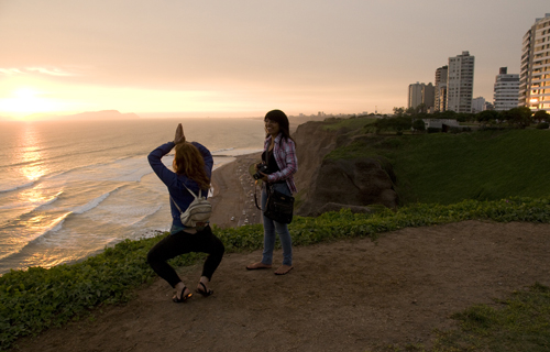
It was hard work, but in our downtime, we were constantly surprised by the city’s chaotic charm and its beautiful coastline cliffs. No one on the road told us we could watch the sun set into the ocean from the cliffs in Miraflores, and it’s probably because the other travelers never stopped in Lima — they only passed through it in bus.
Sure, Lima isn’t set in the pristine Sacred Valley like Cuzco, and it’s often overlooked by people itching to see Machu Picchu, but if you like big-city movement and you’re looking for Peruvian culture that isn’t based on selling llama sweaters, Lima is well worth a visit.
The Way to Doña Selvia’s

Our strange and journalistically productive stay began with Wayrary, a traveling merchant from the Peruvian Amazon. He got his start selling knife sharpeners in the streets and worked his way up to selling jewelry and metalwork.
We met this dreadlocked fellow in Barranco while looking for a place to stay and he brought us to Doña Selvia’s house. Doña Selvia was 54, but she looked about 74 and needed crutches to walk. She never planned on running one of Lima’s cheapest, crummiest hostels, but she had been neglecting her utility bills and needed cash.
The place was unique. Doña Selvia’s 86-year-old mother slept in the grapevine courtyard, a family of mice lived under the gas range, and Ania and I slept on old cots in a hallway full of dusty pots, pans and Jesus paintings. It was basically urban camping since none of the utilities worked, but we paid $1.50 a night and that was much easier to handle than the $15-$25 hostel rates in the rest of the city — especially when compared to the popular Miraflores backpacker’s hostels.
Regardless of the conditions, Doña Selvia was probably the happiest person we met on our journey and Ania and I settled in among a crowd of street merchants, magicians and jugglers. They were great people. Especially Wayrary, who had been living in Lima on and off over the last 10 years. He was full of Lima knowledge and would show us around the city when we weren’t hunting down Peru’s evasive government elite.
Exploring the City; Exploring the Galleries
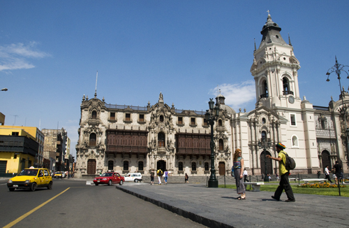
In Lima, the avenues are so wide they seem to be made for cargo boats, not cars, and city block can be so large they can make a person feel worthless. While walking around the center, it’s easy to see Spanish colonizers were tired of their overcrowded cities back in Europe and they took the opportunity to really stretch out in the new space of the “New World.”
Ania and I stood in Plaza de Armas and listened as Wayrary talked about Lima’s golden colonial days. “Golden,” as in Inca gold. The city made its early fortunes shipping precious metals to Europe and became a hub of wealth for the Spanish Empire. Lima became a place reserved for the ultra-elite of the colonial times and eventually became the first city to have electricity in South America.
Of course, much has changed as slums now cover the majority of the dusty mountains around the city, but between the grandiose colonial architecture and the abundance of fine-art institutions, it’s not hard to find remnants of Lima’s “golden” days in the city center.
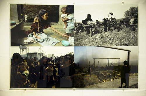
Ania, Wayrary and I paced slowly and silently through a multitude of galleries and museums and were impressed with the exhibits, which seemed to favor contemporary photography above other art forms at the time of our visit. There were street shots of stylish Lima residents from the 1960’s, photo essays on campesinos digging wells in the Andes, and most striking of all, there was a large exhibit on the history of political violence in Peru.
Ania and I stood coldly in front of war images as Wayrary explained the practices of Sendero Luminoso (Shining Path), a Maoist guerrilla organization in Peru’s highlands. It wasn’t common practice, but some Sendero soldiers were known to imprison women in secluded villages and force them to produce large numbers of children to supplement the group’s military forces. Those who resisted were not fed until they complied or faced death by starvation.
“The only difference between these women and me is that I was born in Canada,” Ania said as we left the gallery. At the end of of the day, we headed for the warmth and the colors of the Mercado Central to shake off the heavy mood and listened as Wayrary gave us insight into some of the national dilemmas:
“When we try to understand ourselves as Peruvians, we only get confused,” he said. “We look at our past and see ancient empires and the Incas and realize we have nothing to do with them. Then, we look at the future and see Europe, Canada and the United States, and realize we have nothing to do with them either. Our present state of being is without roots and, because of that, we lack a natural direction for our future. We are a people lost in a the middle.”
Leaving Lima

In the process of conducting interviews with government officials, Ania and I did a few loops around the entire metropolitan area of Lima. There was a lot to explore and it looked worthwhile, but we were too busy transcribing, translating, and transliterating to see it all.
Every evening we took a table at the Barranco Starbucks and used the free Wi-Fi connection to do research and send updates to our editors. We never bought a single coffee and felt the thrill of adventure as the upper-class women of Lima sat around us, chit-chatting and eating muffins with forks and knives.
Eventually, we got the information we needed and submitted our articles on the widely protested Conga gold mine project. Our mission had been accomplished.
In the time we stayed at Doña Selvia’s, Ania and I managed get an upgrade from our hallway cots to one of the few rooms in the house. Though we showered with buckets and cooked with flashlights, it was probably the most pleasant “hostel” we found since Panama City and we were sad to go.
Our last night, Ania bought tofu in Lima’s Chinatown and cooked dinner for everyone. We gave Doña Selvia a plate and she was so happy that she said she’d “never forget about the time a Canadian cooked me Chinese soy cheese,” and then started singing while she cleaned the kitchen in pitch black darkness. For some reason, she always cleaned in the dark.
We got back on the road in the morning, this time heading for Cuzco and then Bolivia. I don’t know if I would recommend Doña Selvia’s house to all travelers, but if you find yourself in Lima, have low standards and need a cheap place to stay, go to Barranco and ask a street vender for the address. Everyone knows Doña Selvia.

Coming up next from Pan-American Transmissions: Into the Amazon: Bolivia’s Gateway to the Jungle
By Diego Cupolo
About the Author
Diego Cupolo is a freelance photojournalist currently on the road to Tierra del Fuego. Most recently he served as Associate Editor for BushwickBK.com, an online newspaper in Brooklyn, and his work has appeared in The New Yorker, The Atlantic, The Star-Ledger, The Australian Times, Discover Magazine and many other publications. View more of his work at DiegoCupolo.com.
The post Lima: It’s Not As Gray As They Say appeared first on The Expeditioner Travel Site.
]]>The post Into The Andes: The High Road Through Ecuador appeared first on The Expeditioner Travel Site.
]]>
Pan-American Transmissions: Part 8
“Pan-American Transmissions” is a travel series from Special Contributor Diego Cupolo as he travels south from Nicaragua to Argentina. He has few plans, a $10-a-day budget and one flute-playing gypsy companion. Check back as new dispatches are posted from the road.
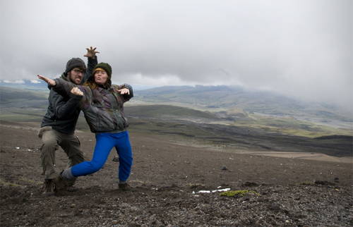
When Ania was a little girl in the Quebec countryside, her parents would lock her outside the house with her sister and tell the two to explore the forest until dinner time. No exceptions. On weekends, Ania’s entire family would go to the nearest mountain and run, not hike, to the summit. Once they reached the top, they would catch their breaths and then run back down. It was their way to exercise.
Through these rituals, Ania grew to be a first-class outdoorswoman. She had the heart of a mountain goat and the thirst of a camel. In her eyes, sitting still was a disease and she became anxious after spending so many months laying around on beautiful Caribbean, white sand beaches. Poor Ania — she needed a challenge. I, myself, was ready for a change of pace.
This was the mentality as our bus crossed into Ecuador, what many call the “Heart of the Andes.” Ania gazed out the window and smiled as she watched the surrounding mountains grow higher and larger, while at the same time, I sat in the aisle seat and watched the people around us grow shorter and rounder. We were in Andean country.
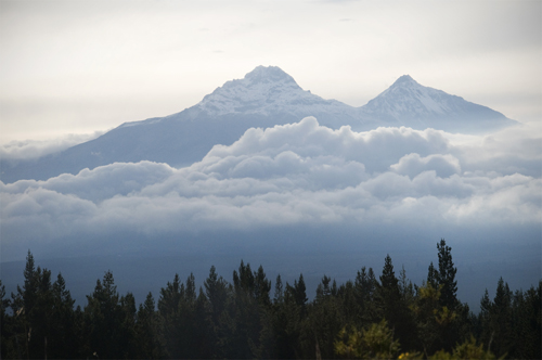
A new stage had begun in the journey. The mountain peaks passed by our bus, commanding our stares, calling our names and flute-heavy folk music echoed from ingeniously-wired speakers. We were excited. Thrilled. Few places in the world offer as much high-altitude magnificence as Ecuador and, by pure luck, we entered the country just as President Rafael Correa dropped entrance fees on all national parks. It was a hiker’s free-for-all — Ania’s dream come true.
We wasted no time. The flip-flops came off and the hiking boots were strapped on tight. We were determined to hike the Andes mountain range until our legs told us we could go no further. We started with the Imbabura Volcano and worked our way south to the Chimborazo Volcano, which is known to be the furthest point from the center of the earth (No, it’s not Everest — I’ll explain later). It took some time to get used to the high altitude and the low oxygen levels, but once we did, Ania and I shared some of the best hiking experience in our lives along the fabled cordilleras. The following are four accounts of four unconventional, low-budget, barely-planned climbing expeditions in Ecuador.
1) Imbabura Volcano – 15,190 ft (4,630 m)
The first stop was Caluqui, a small, indigenous village near Otavalo where the barbarous Imbabura Volcano watches over fertile mountain valleys. The year before, Ania had lived with a family in this mountainside community as part of a university program, so we paid her hosts a surprise visit. When the mother opened the door, she saw us and broke down into tears as the kids jumped around happily. The red-haired “Tia” had returned.
The family was so delighted to receive us that they killed a fresh chicken for dinner. We stayed at their place for about a week. Every morning Ania and I ate breakfast in the kitchen with our eyes gazing out the window at the Imbabura. The mighty volcano was practically at our doorstep and we watched the summit, waiting for the right conditions to start climbing.
Then, when the first clear day arrived, we set out early in the morning. The family told us there were no direct trails to the summit on our side of the volcano so we packed lightly — two apples, a few pieces of bread and one liter of water — thinking we’d go out for a short, easy hike. Nothing extreme.
We started walking. We passed through another small indigenous community and, soon enough, we began ascending the steep base of the volcano through patches of aqua-green eucalyptus trees. They smelled nice. Except for the occasional herd of grazing cows, Ania and I were completely alone with the land. We felt good. We were finally hiking the Andes.
We went up and up, crossed a gorge and continued up and up until we hit a thick wall of prickly berry bushes. “We’ll just go around,” I said. Neither of us felt like stopping so we walked along the volcano’s flank, looking for an opening in the bushes. We looked and looked, but never found one.
“Well, how far do you think the bushes go up?” Ania wondered. “They have to stop eventually. Let’s just try to make our way through.” I agreed and we ducked into the jungle of prickers and thorns. Each movement required planning. Every direction induced pain. The bushes were so thick we couldn’t stand up and we soon found ourselves crawling on our hands and knees through mud and moss and spikes of all sizes.
It went on like this for a half-an-hour before we realized the thorns weren’t ending anytime soon. Sure, it was miserable, but we figured it wouldn’t last much longer and kept pushing our way up the volcano through the thorns. An hour passed. Two hours passed. We were still in the berry bushes and we were getting tired. By this point we were well above two miles in altitude and it was getting hard to breathe. To make things more challenging, our hands were scratched to hell, our water had run out and we had consumed the little food we had in our bags.
“Okay,” I said. “I know it doesn’t sound right, but by now it’s probably easier to keep climbing up, get out of these bushes and try to find a trail back down. If we turn around here we’ll just spend another two hours in these damn thorns.”
We pushed and rolled. We became stuck; lacerated. Then, after three hours of pure torture, we popped out of the berry bushes into the yellow grasslands below the summit. It was a victorious moment.
Literally, “a” victorious moment. We dragged ourselves through the yellow grasses, without water, gasping for air, and couldn’t find a single trail. It was then that, reality gave us a firm slap in the face as we realized there was no way back down other than to go through the berry bushes . . . again.
Looking back on it, you could say passed a brief episode of pure crisis in that thick, yellow grass. The sun was low in the sky. It was starting to get cold. I didn’t know what to do and Ania started yelling violent obscenities in Quebecois French.

Lacking better options, we walked back down to the wall of bushes — tired, exasperated — took a moment to think things over and then dived head first into another three hours of thorns and pain. This time, at least, we used a pair of long sticks to aid the process.
Night had fallen by the time we came out the other end, scratched and angry (at ourselves mostly). We raced down the volcano’s foothills, found the nearest store, bought a big bottle of water and finished it within seconds. It was 9 p.m.when we got back to the family’s house, meaning 13 hours had passed since we left for our “short, easy hike.”
The mother laughed at our story and served us potato soup with quinoa. As I ate, I looked over my bleeding hands and I reflected on the miserable day. Maybe we were too eager to climb the Imbabura. Maybe we should’ve planned things out a little better — brought more food and water for instance. But one thing was certain: this was the wrong way to climb a volcano.
2) Cotopaxi Volcano – 19,347 ft. (5,897 m)
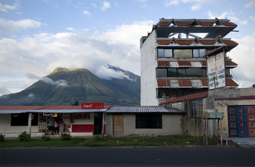
The thorn wounds were still fresh on our hands when we reached the Cotopaxi, Ecuador’s second-highest peak. Fortunately, this hike would play out much differently than the first. Cotopaxi is just south of Quito. On clear days its white, perfect cone is visible from the city center and it is beautiful, almost pornographic for high-altitude climbers.
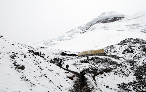
Reaching this volcano’s summit is a serious matter. The Cotopaxi is so high it requires ice gear and professional guides (which at the time charged about $200 per person). Tour groups normally climb to a mountain refuge at 15,748 ft., eat, sleep in cots for a few hours, and then wake up at 12:30 a.m. to climb the rest of the way, reaching the top just as the sun rises. We were told tour operators climb at night because the snow is frozen hard and easier to grip with crampons, whereas during the day, the snow melts and is prone to avalanches.
Ania and I would have liked to reach the summit, but it was complicated and out of our budget. Instead, we took the easiest approach to climbing Cotopaxi and hitched a ride to a parking lot just above the Volcano’s snow line at 15,092 ft. high. From there, we joined other visitors who leave their cars and climb 656 ft. (200 meters) to the mountain refuge.
It sounds easy like an easy task, but it turns out to be a treacherous one-two -hour hike for the inexperienced. The path is not long or complicated, it’s simply the lack of oxygen at these elevations. The Cotopaxi put us in shame. A profound sense of worthlessness overcame my ego as I took three strides and gasped for air. It happened to all the visitors. About halfway up, a we saw a German girl vomiting her life because she hadn’t brought water. High Altitude Tip #1: drink excessive amounts of water.
When Ania and I got to the refuge celebrated by rolling in the snow. We sat down to eat cheese sandwiches and enjoyed the views. Cotopaxi is surrounded by gigantic, treeless, red, black and brown lava basins. Having so much open space present itself before us awakened strange, unknown senses. Our bodies where revitalized.
When we were done, Ania and I ran back down the volcano, passed the parking lot, and once again made our own path (this time keeping an eye on the nearest road). We surfed all the way down Cotopaxi’s side, sliding through mounds of black cinder until we reached a red canyon where an old lava flow had frozen in time.
The sun was shining, a group of wild horses galloped through the bare land and we took a promenade through the endless romance of it all. At the end of the day, we got back on the road and hitchhiked back to Quito. Easy.
The freedom we experienced on those bare lave plains made for one my favorite experiences of the voyage. No guides. No tour companies. Not even a single noise. It was just Ania, myself and the mountains. (Insert howling wind sound.)
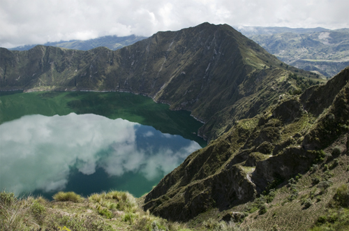
3) Quilotoa Crater Lake – 12,841 ft. (3,914 m)

One of the Andes’s most serene landscapes was created by one of its most violent explosions. Two miles in width and about eight miles around, the Quilotoa caldera was formed after a VEI-6 eruption rattled the planet about 800 years ago. The blast was so powerful its gas plumes and muddy lava flows reached as far as the Pacific Ocean — just under 200 miles away.
As time passed, the dust settled and green, mineral-rich water filled the caldera to create an almost paranormal lagoon that has inspired many native legends about condors, falling feathers and lighting bolts. Today, visitors can easily access the lagoon by hiring a truck ($2 per person) from the nearby Quechuan village of Zumbahua. Some mountain lodge-style accommodations have recently been built near the crater, but they’re small, family-owned and charged between $7-$20 a night (meals included) at the time of our visit.
Regardless of new developments, the place remains beyond pristine, almost beyond words. Ania and I stood in shock the first time we looked over the ledge, down into the fluorescent waters of the lagoon. My eyebrows reached new heights on my forehead.
It may sound strange, but at first sight, the water in the Quilotoa was blurry, like something was floating above it. Inside it. It’s hard to describe. I stood there for a while, squinting my eyes, until I could make sense of what I was looking at — the waves, the clouds, the colors — and then, took a photo. But it was worthless. In an place so immense, an environment so ancient, what could a photo really capture?
I sat down and told Ania I wanted to stay by the crater side for at least a week. It seemed like a place that needed to be taken in slowly. Fifteen minutes later we got up and started walking the crater’s perimeter. The hike turned out to be one of the most scenic, least difficult expeditions we found in Ecuador. There was a photo in every direction I pointed my eyes.
Experts can hike the perimeter in about three hours, but casual hikers probably need four-five hours to do the loop. There are various ups and downs, making the hike challenging at times, but nothing too serious, and the altitude here doesn’t play as big a factor as it does on the volcanoes. It is also possible to hike down into the lagoon — a two-hour roundtrip.
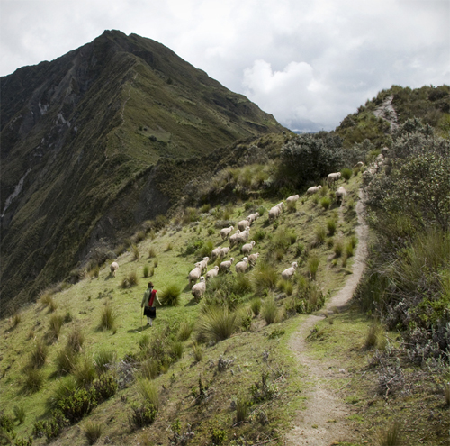
Ania and I spent the day exploring the Quilotoa, taking breaks to take in the views, and chatting with the occasional sheep herder, though few spoke Spanish. It’s Quechua country in these regions and, until recently, the area was only populated by poor, ultra-isolated potato farmers. Tourism is still new to them.
By mid-afternoon, the clouds came in with a cold wind and swooped down into the caldera. Ania and I hurried back to our small lodge where alpaca blankets awaited us. The old housekeeper made chicken soup when we arrived and the long day ended as we huddled close to the fireplace in our little room.
It could’ve been the ideal honeymoon. All in all, the Quilotoa crater lake was our most enjoyable hiking experience in Ecuador. Simply writing this makes me wonder why we left . . .
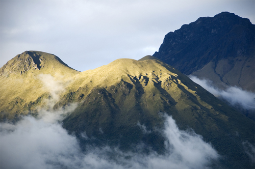
4) Chimborazo Volcano – 20,702 ft. (6,310 m)
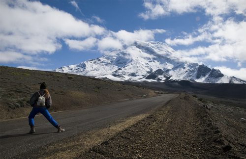
We saved Ecuador’s biggest volcano for the finale. While the Chimborazo is not as far above sea level as Mount Everest (29,029 ft.), it’s location near the equator makes it the furthest point from the center of the Earth. How’s this possible? Equatorial bulge. Centrifugal force caused by the Earth’s rotation basically stretches the planet’s crust outward into space. This pushes mountains near the equator further from the Earth’s core than mountains elsewhere on the planet.
Taking all this into account, Ania and I packed well for the expedition. Like the Cotopaxi, a tour company was needed to reach the summit and that was out of our budget, so we geared up as best we could (Ania bought an jacket from an old lady) and we headed out for our last great climb in Ecuador.
A cheap bus can be taken from the nearest city, Riobamba, to the volcano’s entrance, which starts you off at 15,912 ft. high. The trail up to the Chimborazo was a mix of black cinder, ash and volcanic rocks. We passed a few groups of llamas feeding on high altitude mosses, but they were shy and ran off whenever we tried to approach them.
We climbed and climbed. It got colder and colder. Sometimes it snowed and iced, but nothing could stop us this time. Ania and I had grown accustomed to the altitude by this point and we finally had the physical conditioning necessary to take on such a gargantuan mountain. Onwards! Upwards!
At some point we reach a mountain refuge that stood at 16,404 ft. above sea level and decided to duck indoors to warm up and eat lunch: apples, carrots, one loaf of bread and one big block of cheese. The high altitude deluxe.
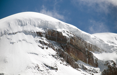
We digested, took advantage of the fireplace, and headed out again to see how high we could go. The clouds came and went, reducing visibility to a few yards at times, but when it cleared up, we were able to catch glimpses of the summit — the furthest point from the center of the earth — and it didn’t look so far from us.
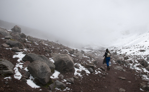
The block of cheese empowered us and we kept climbing until we reached a frozen lake that was about 17,200 ft. high. Soon after a thick fog engulfed us. It was a complete whiteout and the humidity brought a chill so crisp and brittle that we shivered down to our bone marrow.
But we enjoyed the moment. There wasn’t a single sound in the air, only the occasional chattering of teeth. The climb was an achievement. Neither I nor Ania had ever reached a place so high in the sky with our own two feet. We relished the moment and then ran back down the icy snow to warm up in the shelter one more time.
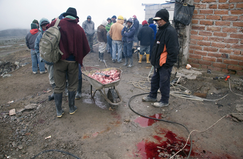
It snowed as we descended and the snow turned into rain by the time we reached the park entrance. There we found a group of construction workers that had just slaughtered a pig. They held up a jug of grain alcohol and gave us two big swigs each before inviting us to feast with them. It was the perfect ending to our journey. We ate greasy, fire-charred pieces of pork, took a few more swigs from the bottle, laughed, danced, and then thanked the group before hitchhiking back to Riobamba with a profound sense of satisfaction.
A Thirst for Climbing, Quenched
After our Imbabura mishap, Ania and I learned to better prepare ourselves for high-altitude hiking. Each time we climbed we were better fit for the conditions. It took weeks to acclimatize to the altitude, and each time we made it up the mountain we shared the Andean landscapes with fewer people than animals. How could we forget the experiences we had with the cows of Imbabura, the wild horses of Cotopaxi, the sheep herds of Quilotoa and the llamas of Chimborazo?
Maybe these animals had a special meaning or link with the mountains. Maybe they didn’t. The point is we were able to enjoy Ecuador’s premier hiking destinations on our own, freely, without tour groups, time schedules or any form of organization. Every hike was whatever we made of it and each expedition proved to be an extraordinary experience.
Most importantly, Ania, the Quebec mountain girl, got what she was looking for in Ecuador’s Andes. Her mountain goat heart was beating at ease. Thin air will do that to a person. The two of us thanked Correa for letting us into his parks for free and then strapped on our backpacks to head south to Peru.
By Diego Cupolo
Coming up next from Pan-American Transmissions: Lima: It’s Not As Gray As They Say. Read all of the other Pan-American Transmissions entries here.
About the Author
Diego Cupolo is a freelance photojournalist currently on the road to Tierra del Fuego. Most recently he served as Associate Editor for BushwickBK.com, an online newspaper in Brooklyn, and his work has appeared in The New Yorker, The Atlantic, The Star-Ledger, The Australian Times, Discover Magazine and many other publications. View more of his work at DiegoCupolo.com.
The post Into The Andes: The High Road Through Ecuador appeared first on The Expeditioner Travel Site.
]]>The post Medellin: A Tale of Two Cities appeared first on The Expeditioner Travel Site.
]]>
Pan-American Transmissions: Part 7
“Pan-American Transmissions” is a travel series from Special Contributor Diego Cupolo as he travels south from Nicaragua to Argentina. He has few plans, a $10-a-day budget and one flute-playing gypsy companion. Check back as new dispatches are posted from the road.
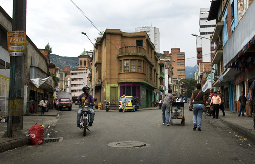
Fourteen-year-old hookers stand at the corner from Medellin’s central plaza waiting to be picked up by the next businessman on lunch break. They stay there every day in groups of three or four chewing pink bubble gum under the shade of “voluminous” Fernando Botero sculptures.
When the girls are done working, they walk home to the Zona Rosa (Red Light District) or go up into the mountains, to the brick-red tsunami of slums that surrounds the city. Their white-collared clients, on the other hand, go far south to El Poblado, the wealthy, tree-lined neighborhood full of shopping malls, fashionable bars and fashionable restaurants. The two groups tuck into bed on opposite sides of the city, but each lunch hour they meet in the center to get what they need from life: money and more exciting ways to use it.
Few regions in the world demonstrate the gap between the rich and poor more dramatically than Latin America and for those interested in exploring both sides — diving headfirst into both sides — few cities in the world display the two realms like Medellin, Colombia.
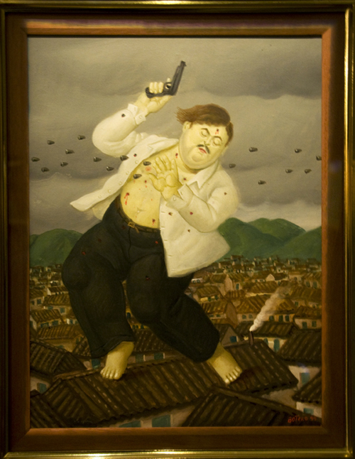
Once home to Colombia’s most notorious drug-trafficking cartel, Medellin began adopting a series of progressive policies after Pablo Escobar’s assassination in 1993. The city quickly shifted into “renaissance mode” by expanding social programs and health services, but most notably, by installing a pioneering public transportation network that connected its poorest residents to the city center.
Today, people living in mountaintop comunas (slums) can get to downtown metro lines via cable cars in less than 30 minutes. The goal was to give more residents a chance to work and study in the city center, a measure that’s being lauded throughout the continent.
What this translates to for visitors is: 1) Unprecedented access to poor areas and life outside the center, 2) Cheap cable car rides above an endless network of slums, full of unimaginable urban scenery, and 3) A taste of what Latin America is really about.
Ania and I spent a couple weeks exploring the two sides of Medellin. One week in the gritty Red Light District. The other in the posh El Poblado district. The experience left a big ball of injustice in our throats and a book full of stories in our heads. The following is a 21st century Tale of Two Cities.
Medellin One
The Afro-Caribbean whores at the front door told us not to stay there because it was “indecent”; the owner told us not to stay there because “he charged hourly rates, not daily”; and the cleaning lady, well, she didn’t really care. It took a little convincing, but with a few jokes and some shameless effort we got into Hospedaje Media Luna on Avenida Bolivar, a cheap sex hotel in the middle of the Red Light District. The room was $5 a night and it came with clean sheets, a private bathroom, a television and free mini soap bars.
It was surprisingly good.
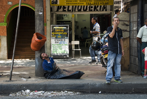
The street outside was a different story. Ania and I went to buy bread and in one block’s distance we saw about 15 tales of insanity, drug abuse and poverty: a homeless man with one leg shooting up on the pavement; an old women dragging 50 filthy plastic bags, vomiting into the sewer grate; five tranny hookers sitting in a hotel stairwell, wearing nothing but g-strings, making cat calls at the passing traffic; a crackhead walking in circles, talking out loud to no one in front of a fruit stand; little boys, none older than 11, all huffing shoe glue out of black plastic bags to get a 10-minute high; and a group of plump ladies sorting through garbage in the street, looking for old produce that can be re-bagged and re-sold at discount prices.
All this, and it was only 7 p.m., a few minutes after sunset. I stood with my back against the wall, looked up at the purple sky and figured it was best to get to the hotel before it got any later. We got the bread, walked back to Media Luna, shut the door tight and that’s where we stayed. Ania and I passed our first night in Medellin eating tuna sandwiches and watching Saturday Night Fever in Spanish.
When the sun rose again and the addicts went back to sleep we went out for a walk to the nearby Botero Plaza. It was full of fat sculptures (or as Botero calls them, “voluminous”). Somebody handed us free tickets to the Museo de Antioquia so we entered and looked at more fat people art. It was nice. Classical art with a twist, but repetitive. Regardless, Medellin-born Botero is the most famous Latin artist alive and, along with Shakira, he is the pride of Colombia.

After a few more strolls through the city center, Ania and I took a ride in the cable cars to the slums up high in the mountains. It’s hard to describe the experience. We watched a somewhat functional cityscape turn gradually into a shantytown labyrinth of terrible roads and corrugated metal rooftops. People living in rubble. Kids walking barefoot through black tar rivers, soccer ball in hand. It makes the stomach turn and the mind pound against the skull.
“What is the difference between us and the people below?” I wondered.
“Nothing. Just the place you were born,” a voice responded.
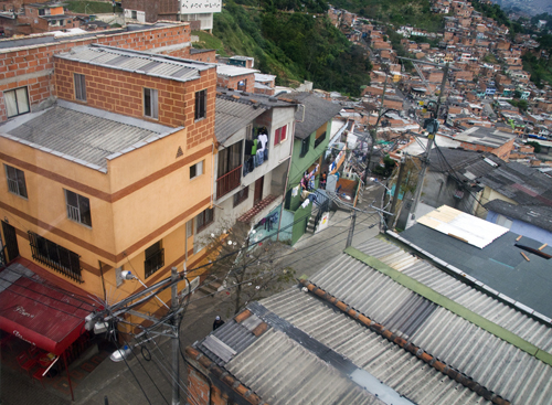
When we got to the top there was a nice, somewhat safe neighborhood to explore. The slum had been slowly evolving since the cable car line was built. There were restaurants, fruit stores and pharmacies. Transportation raises property value, sure, but in slums, any attention at all raises hope.
We found a newly built library full of local schoolchildren, all of them reading books and doing their homework. Ania and I walked around, enjoyed marvelous views of the city and left the slum feeling more optimistic about the world.
Things can get better.
Then we got back to the Red Light District. Ania and I were walking back to our hotel on Avenida Bolivar when a tranny in a bath towel ran out in front of us. Everybody on the block stopped to watch as she dashed across the street and started punching a big Afro-Caribbean mama. It was violent. The big mama was defenseless as both her hands held a big bucket of candy.
The tranny wasn’t slowing down with the punches so the big mama hit her with everything she had: the big bucket of candies. A thousand colored wrappers exploded into the air like fireworks, and the the two came out from the smoke, this time running back across the street. They were both yelling something before they disappeared back into the hotel.
Then there was silence. Just when we thought it was over, the two ran back out. This time the tranny was holding a long piece of plywood and chasing after the big mama. When they reached the middle of the street, the tranny threw the plywood at the big mama and missed. Everyone laughed, some clapped, and the show had become a spectacle. The tranny, red in the face and sweating off her makeup, ran back in the hotel at that point. To my surprise, her towel stayed on the entire time.
As for the big mama, she looked around and breathed heavily for a moment. She seemed confused, replaying everything that just happened in her mind. Eventually, she walked back to her candies — which were now spread out all over the street — and she began picking them up, one by one, as she cried.
It was hard to watch, but after a few quick inquiries we were told the big mama walked out on the tranny without paying her bill. The moral of the story: never cheat a tranny.
Medellin Two
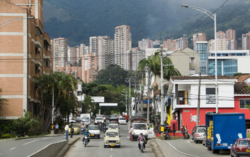
After a week of watching kids huff glue and have seizures in the street, Ania and I decided to move to El Pobaldo, a wealthy neighborhood on the other side of the city. A friend in Cartagena told us we could get free lodging at the Hostal Sunshine on Calle 9 if we worked the reception desk so we followed the tip . . .
. . . and it turned out to be true. A nice Israeli guy with long hair and big pupils owned the place. He gave us work without asking too many questions. The deal was simple: work three shifts at the reception desk and receive one free week of lodging, wi-fi, laundry service and kitchen use — not bad.
We put our bags in our new room and went out to see the neighborhood. It was the polar opposite of everything we saw in the city center. People wore designer clothes, drank Heinekens and spent their time thumbing iPhones as they walked poofy little dogs. The sky was lined with shiny white luxury apartments and the streets were lined with their shiny white electric fences. Green was everywhere. The streets had gardens and trees and nice, clean parks with swing sets and hopscotch. Organic grocery stores existed. There were bars, restaurants and little streams with benches next to them. El Poblado had it all and because of this it was home to the majority of backpackers’ hostels in Medellin.
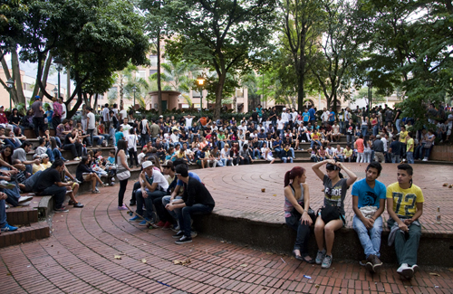
With good reason, too. The neighborhood’s known for its all-night parties and extravagant nightclubs. To put it simply: There’s a lot of blow going around. Unfortunately, Ania and I didn’t have the money, the clothes nor the appetite to get into El Poblado’s party scene. During our stay at Hostal Sunshine we kept living between the two sides of the city (or better said: the two sides of Latin America).
We’d buy cheap groceries from desperate street vendors in the Red Light District and then help manicured tourists call taxis in El Poblado. It took some time and patience to adjust in our new roles as hostel receptionists, but, then again, most of the job involved doing nothing. We cleaned a few things and made sure the bathrooms had toilet paper. Everything was great. Everything was easy.
Until the weekend.
I was assigned night shift on Friday and Saturday. This meant sleeping by the front door to let in the drunks as they stumbled home. I slept on a couch and when someone buzzed, I’d get up, let them in, and watch them walk to the back room with a bottle of aguardiente to keep partying and snorting lines till the next afternoon. How they yelled.
I wanted to sleep, but couldn’t. It was unpleasant, to say the least.
The second night was the same only there was a car robbery in front of the hostel at 3 a.m. A girl was pulled out of her Chevy at gunpoint and the thieves hopped in and drove away. I woke up to the sound of the screeching tires zipping by the front door. When I opened the door, I found the girl crying on the sidewalk so I let her into the hostel to calm down, call the police and shiver for a while as she waited.
By pure luck, the cops tracked down the car in the city center and returned it unscratched. The thieves went to jail.
In the morning, all hostel guests were shocked by the car robbery. These things weren’t supposed to happen in El Poblado, but they did and to rub it in, the next night there was another robbery in front of the hostel. This time it was a purse.
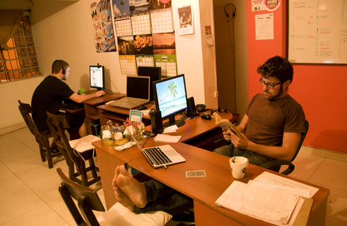
I barely got to sleep that weekend and in my zombie daze I thought over the circumstances in Medellin.
It’s plain and obvious: Even if El Poblado is the city’s safest neighborhood, there’s a mass of people living in deep, wretched misery on the other side of the green parks, the jogging tracks, and the rooftop swimming pools. It doesn’t matter how high the electric fences are built, misery breeds crime that seeps through all barriers.
The scenes Ania and I saw in Medellin happen in all urban areas throughout Latin America and, most likely, throughout the rest of the developing world. It’s not just a few people living in a few slums either, it’s the majority of the world’s population that suffers these unnecessary conditions on a daily basis.
Medellin illustrates a severe tale of inequality, but with its progressive social programs, its mountaintop libraries and its all-inclusive transit system, the city’s also setting an example for the rest of the world: inequality lowers everyone’s living standards, no matter which side of the city we live on. The only way to make improvements is by making sure they reach all parts of a city and benefit all levels of society.
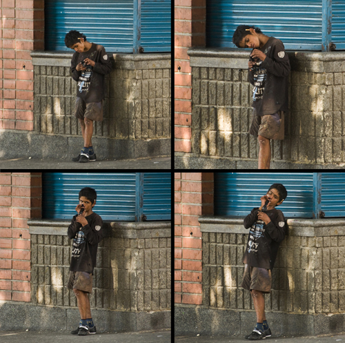
By Diego Cupolo
Coming up next from Pan-American Transmissions: Into the Andes: The High Road Through Ecuador. Read all of the other Pan-American Transmissions entries here.
About the Author
Diego Cupolo is a freelance photojournalist currently on the road to Tierra del Fuego. Most recently he served as Associate Editor for BushwickBK.com, an online newspaper in Brooklyn, and his work has appeared in The New Yorker, The Atlantic, The Star-Ledger, The Australian Times, Discover Magazine and many other publications. View more of his work at DiegoCupolo.com.
The post Medellin: A Tale of Two Cities appeared first on The Expeditioner Travel Site.
]]>The post Pan-American Transmissions Part 6: Capurgana, Taganga and Colombia’s Sweet Caribbean Cacophony appeared first on The Expeditioner Travel Site.
]]>
Pan-American Transmissions Part 6
“Pan-American Transmissions” is a travel series from Special Contributor Diego Cupolo as he travels south from Nicaragua to Argentina. He has few plans, a $10-a-day budget and one flute-playing gypsy companion. Check back as new dispatches are posted from the road.
The FARC is almost dead, and it’s dinosaurs that seem to be alive and roaming through the jungles near Capurgana, Colombia. At least that’s what it looks like from the dock. Ania and I stared in disbelief as our boat pulled into the harbor of the small Afro-Caribbean village.
“Places like this really exist?” Ania asked.
It was hard to take it all in after the long, stale journey through Panama’s Kuna Yala islands. Massive waves exploded into white foam on black stone cliffs, hordes of pelicans squabbled over jagged rock islands and monkeys screamed from the canopies overhead as we disembarked.
“We made it,” I responded.
Pure, wild, tropical paradise without a car in sight — Capurgana is on Colombia’s mainland, but it’s only reachable by plane or boat, making it feel more like a lost island in the Caribbean than a part of any country. Located just south of the Panamanian border, we expected the worst from immigration officers, but they let us pass without checking our bags so we bought a couple fresh mangoes and headed straight to the beach.
It was there, on that fine warm sand, that I realized something about Colombia. Sure, there were rifle-touting 17-year-olds in camouflage patrolling the town’s perimeters, but the place was offensively beautiful. Incomparable to anything in Costa Rica.
With natural gems like Capurgana and Taganga, I wondered what Colombia will become when its internal conflicts are finally resolved. (Which might happen sooner than anyone expects.) Colombia could be — and some say it’s already becoming — a major travel destination and international economic power. The question is: How long will it take?
As Ania and I would soon find out, the Caribbean coast is a good place to start observing the progress for anyone that’s not willing to wait.
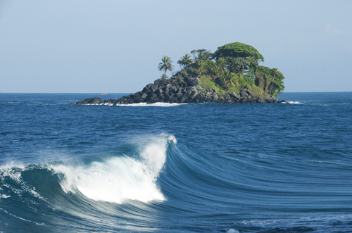
Capurgana: Donkey Carts and Reggae Music
Those resilient enough to get there will be heavily rewarded. Capurgana is gold. A refuge from the rest of the world surrounded by humid green, red mud jungles and pristine cyan waters.
Best of all: Capurgana’s incredibly cheap for everything that it offers. Ania and I found a place to camp for $1.50 a night each. We set up our tent across the street from the sea and went for a walk around town.
The first thing we noticed were the donkey carts — automobiles are useless in a place where all roads end in the jungle. The second thing we noticed was the town center: a soccer field lined with bars, each one playing reggae music as loud as possible 24 hours a day. The competing sound systems made a mix of incomprehensible noise so Ania and I headed towards the more peaceful rhythms of the waterfront.
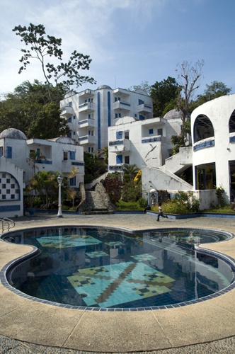 There we found a myriad of trails. Some went through the jungle; others snaked over the rock cliffs by the sea. Both were covered with tiny green and black poison dart frogs. We passed an abandoned mafia palace of a hotel on the way and followed a trail along the sea to a luxurious, natural tide pool. Waves crashed on the rock walls and replenished the fairly large tub of hermit crabs and sea foam as we sat in warm water, wishing we had brought champagne.
When we got our fill, Ania and I followed on the same trail further into the jungle until we reached the home of a lone rasta artist. He asked for donations to enter his garden, but it seemed like a tourist scam so we turned around and returned to our tent.
The next day we joined a group of travelers and followed a trail through the jungle, over an extraordinarily humid mountain and ended up in the neighboring seaside village of Sapzurro — a smaller version Capurgana. It was nice and stunning and all, but locals said the nicest beaches were a little further, just across the Panamanian border in a place called La Miel, so we kept on marching.
The hike was worth it. La Miel has some of the highest ranked white sand beaches in the entire Caribbean. Some places have a trash problem, but we got away from the main beach, found our spot among flower bushes and cracked open coconuts the rest of the afternoon as our friends practiced their juggling.
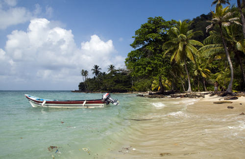
I could’ve easily stayed there for the rest of my life — in La Miel, in Sapzurro, in the sweet raw smell of everything around Capurgana — but the voyage had to go on. Too much beauty can deteriorate the mind.
Taganga: Choose your Beach, Choose your Fish
Ania and I rode a speed boat like a skipping stone to a port on the mainland called Turbo. From there we hitchhiked all the way to Cartagena with a Swiss couple that wouldn’t admit to being a couple and our old Argentine friend, Felix. The process took a few days and involved riding in a brand new Renault sedan latched on the back of an 18-wheeler along with seven other cars bound for a city dealership. (How else could five people catch a ride together?)
Cartagena was fine, and it’s good for drinking and partying — just stay in the city center! — but Ania and I got bored and continued east to Taganga, a fishing village turned hippie/backpacker mecca.

After Capurgana we thought we had seen everything Caribbean Colombia had to offer, but Taganga was beautiful in a completely different way. It was much drier. Cactus stubs dotted sandy coastal mountains that dropped straight into the sea. The rugged terrain formed countless tiny beaches, accessible by boat or hiking, and the choice of where to lay our towel was about the only thinking we did during our stay.
By that point we had thoroughly marinated in the Caribbean culture. Once you absorb it, it’s hard to get away.
Many travelers visit Taganga because it’s the cheapest place in the world to get scuba diving certification. Good to know, but Taganga’s also next door to some of Colombia’s main attractions, Tayrona National Park, and the mysterious Ciudad Perdida, the ruins of an ancient city hidden deep in the park’s jungle.
Regretfully, Ania and I didn’t go to either of these places because it was high season and the entry fees were doubled. What we did do was hike around the desert mountains until we got too hot and then went swimming. The scenery in Taganga was enough for us. It didn’t feel like we were missing much. To top it off, at the end of each day, we’d stop by the fishing boats and pick out fresh barracuda to grill for dinner.
Life was simple and life was delicious. On the edge of town, we found a hostel that charged $1.75 a night for pitching a tent and slipped into yet another crowd of ragtag Argentinians that sang all night and drank all day.

The only problems in Taganga are directly linked to the heavy tourism. The infrastructure can’t handle many people and the water runs out sometimes. (I brushed my teeth with purple water leftover from boiling beets for a few days.)
Taganga’s also known for its never-ending supply of hard drugs. It’s easy to get lost in it, but also easy to avoid it — your choice. I didn’t think much of the scene until I found a bag of coke on the ground. I picked it up and offered it to a girl selling arroz con leche in the street and she gladly accepted. To my surprise, she wouldn’t give me a free cup after the gift.
Ania and I roamed around Taganga for a few more days, then we finally gathered up enough mental strength to pull ourselves from the lazy Caribbean shores and explore the rest of the country.
It was necessary. We were losing track of time.
We hit the road again and caught rides form town to town. Hitchhiking in Colombia turned out to be much more challenging than in other countries, but somewhere en route to Medellin, a young engineer gave us a nice lift. He was educated and informed so we talked for a few hours about Colombian politics, the FARC and narcotrafficking. He said he was glad to see more tourists in the country.
“Too many people focus on the negative side of Colombia, but you’ve seen how beautiful our land is, you know we’re not all selling cocaine. There’s a small number of bad people giving the rest of us a bad global image,” he said.
In the end, he said he was confident things would change for the better.
“Colombia’s moment is coming,” he said. “The FARC is getting weaker every month. They have no direction. They’re just a bunch of young kids that are running out of ideas and, pretty soon, we’ll be running them out of this country.”
To this day, I still think about the possibilities . . .

By Diego Cupolo
Coming up next from Pan-American Transmissions: Medellin: A Tale of Two Cities.
About the Author
Diego Cupolo is a freelance photojournalist currently on the road to Tierra del Fuego. Most recently he served as Associate Editor for BushwickBK.com, an online newspaper in Brooklyn, and his work has appeared in The New Yorker, The Atlantic, The Star-Ledger, The Australian Times, Discover Magazine and many other publications. View more of his work at DiegoCupolo.com.
The post Pan-American Transmissions Part 6: Capurgana, Taganga and Colombia’s Sweet Caribbean Cacophony appeared first on The Expeditioner Travel Site.
]]>The post Pan-American Transmissions Part 5: 10,000 Ways From Panama To Colombia, None Of Them Paved appeared first on The Expeditioner Travel Site.
]]>
Pan-American Transmissions Part 5
“Pan-American Transmissions” is a travel series from Special Contributor Diego Cupolo as he travels south from Nicaragua to Argentina. He has few plans, a $10-a-day budget and one flute-playing gypsy companion. Check back as new dispatches are posted from the road.
The Pan-American highway runs from the top of Alaska to the bottom of Argentina with only one interruption known as the Darien Gap. In this void of paved roads and humanity lie 100 miles of rugged jungle terrain that separate Panama from Colombia – Central America from South America. If an overland route does exist, it’s unmapped, lined with poisonous snakes and patrolled by narcotraffickers.
Nobody told me this before Ania and I set out for Tierra del Fuego. Call it ignorance, call it adventure. It’s all the same in the end.
The gap posed a challenge for our journey and we weren’t prepared to pay for a flight. Ania and I spent our free time in Panama City interrogating travelers to find a practical solution. Many suggested the airport. They said it was affordable, but we wouldn’t listen. At some point, we met a woman that crossed the gap on foot. She was alone for seven days in the jungle and slept with a machete in her hand.
She didn’t recommend it.
Then, after extensive research, we learned about the sea routes. Thousands of boats cross between Panama and Colombia every month. Some are made for passengers, others are made for diesel fuel but take passengers anyways. At the time we crossed, boats on Pacific routes charged between $55-$200 a person and boats on Caribbean routes charged $25-$750 a person (tour boat prices rise every year).
On both sides, the cheap rides were on commercial cargo ships. The higher prices were mainly for Caribbean package tours that include snorkeling, island tramping/camping and fine cuisine en route to Cartagena, Colombia.
Ania and I decided to go with Cargo Boat Captain Sierra. We got a piece of paper with his three telephone numbers on it and were told he would take us through the Comarca Kuna Yala (aka San Blas Islands) — a sovereign indigenous territory in the Caribbean made of more than 400 small islands — until we reached a Panamanian military post at the Colombian border called Puerto Obaldia. It would be a five-day ride on a 50-meter steel cargo boat. The cost: $50 a person.
Cheaper cargo boats do exist, but they’re slower, sometimes taking 10-14 days to reach the border. Either way, Captain Sierra was the cheapest we could find at the time and we figured the journey would make for an interesting cultural experience.
Stranded in Carti
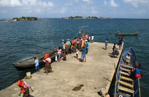
After 45 phone calls, we got in touch with Captain Sierra. He said he’d pick us up in a place called Carti at 7 a.m. on a Saturday morning.
He never showed up.
We sat on the dock all day with four Argentinians from Hostal Miami. There was Felix, a law school dropout turned professional juggler, and there was Eleana and Santiago, a nomadic hippie couple traveling with their ravenous one-year-old daughter, Youla.
The six of us had no choice but to sit and wait for Captain Sierra. There wasn’t much else we could do on that tiny port island in the Kuna Yala. Carti was so small it took seven minutes to walk around the whole thing. Swimming was out of the question since water surrounding the island was full of trash and raw sewage (outhouses were built on piers over the sea). And, to top it off, the locals wouldn’t talk to us – especially the women – and the only restaurant in town had already kicked us out for sleeping under the tables.
In the afternoon, I woke up near the dock and watched a Chilean sailor park his yacht. We told him about our situation and he offered to take one person to the border, free of charge. Ania and I weren’t going to part and the same was true for the hippie couple, so Felix jumped on board. We watched him float away into the sunset with dolphins jumping beside the yacht and pelicans flying overhead.
Lucky bastard.
The night came quickly after that. Ania wanted to set up our tent, but the little island was packed full of thatch huts. There was absolutely no space for another structure in Carti – no matter how small it was. As we scratched our heads, a local family took in the hippie couple because they had a baby. Ania and I hoped for the same, but we were left in the street.
We unrolled our sleeping bags beneath a ledge in the school courtyard and laid down with our heads on our backpacks. Locals walked by and shined their flashlights on us, but otherwise, they left us in peace.
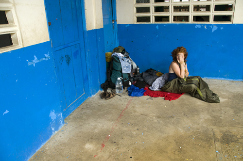
It went on like this for four days. Ania and I sat on the dock with the hippie couple, reading, eating overpriced canned food, playing with Youla, feeding Youla, getting shunned by locals, waiting for, hating more, all because of Captain Sierra.
Few boats passed by. When they did, they were usually speed boats that took passengers directly to Puerto Obaldia in one day for $100. It was tempting, but at that point, Ania and I still believed Captain Sierra would arrive at any moment. Every time a horn sounded in a distance we ran to the edge of the dock and scanned the horizon. There was usually nothing. After a while, I started wondering if I actually heard the horns or if I was just getting delusional.
The zombie monotony broke on the third day. A Royal Caribbean cruise ship set anchor off shore and the locals went into mass hysteria. All the women rushed to set up tables outside their thatch huts. They filled the streets with colorful souvenirs and hand-sown fabrics called molas. Little boys put on funny costumes and little girls put parrots on their heads. One older woman sat by her souvenir table with a lemur in her lap. She wore the traditional Kuna Yala explosion-of-color apparel and charged $1 per picture – as did everyone else.
Thick North American tourists were then shuttled onto the island and toured Carti – all seven minutes of it – with the help of local guides. They bought molas, paid for pictures, and the local women smiled. Not once in three days had they smiled at Ania and I and now we knew why.
I asked the cruise captain if he could take us to Colombia and he said no. Shortly after, all the tourists went back to the motherboat and life went back to careless stagnation on the island. The afternoon turned into night and nothing happened for a long time.
Then, out of that nothingness, a Russian appeared. His name was Sasha. He was waiting for one of the $100 speed boats. We bought a few beers and he told us a story about some people he knew that were crossing to Colombia on package tour boat and got stranded. The captain had let them off on a deserted island and sailed away with all their belongings while they swam and tanned in the sun.
They were stuck on the island without food or water for five days.
“Okay, I guess we don’t have it so bad here,” I said.
After that, Sasha told us about a train that runs straight across Russia. The Trans-Siberian Railway. A week-long journey from Moscow to the Sea of Japan for $200.
In that muggy tropical air, over those warm beers, I took a moment to picture the Russian arctic tundra in my head. Siberia sounded damn good after three days in Carti.
Saved by Azalea 1

Luck came with the sunrise. I woke up early the next morning to find Santiago shaking my leg.
“Get up! Get up!” he said. “We found a cargo boat. It’s leaving for Colombia in 30 minutes. Get your stuff together and let’s get the hell out of here.”
Her name was Azalea 1 and she looked so beautiful in her rusty coat, floating over that raw shit water in the morning light. The six-person crew was pure Kuna Yala. Some barely spoke Spanish. The captain charged $75 a person for a three-day ride to Puerto Obaldia. It was more than we wanted to pay, but the five of us jumped on board, thrilled by the idea of actually leaving Carti.
The engine started, the exhaust pipe spit out black smoke and I smiled as I watched the island fade into the morning haze.
I then took a minute to inspect our cargo. The amount was impressive. Despite being just 30 meters in length, the Azalea 1 was hauling such an extensive variety of products that it could only be matched by Wal-Mart. Gas canisters, door frames, bed frames, refrigerators, washing machines, tricycles, beer, sheets of corrugated metal, televisions, mattresses, potato chips, tuna, gasoline-powered generators and about 100 sacks of dry cement mix. We had everything, but space.

On our way to Colombia, the boat stopped at different Kuna Yala ports to drop off supplies. Each time we docked, the entire population on the island swarmed the boat and watched as we pulled items out of the hull. They wanted to see if the chief would finally get that television he ordered for the community center. They wanted to know how many beers they could drink until the next cargo boat passed.
Santiago and I helped the crew unload supplies. Just imagine trying to fit a full-size refrigerator in a canoe. This is how island people live.
At night we would dock at a pier and cook dinner. The captain told us we would eat fried fish and rice throughout the journey, but he mostly fed us canned hot dogs. He’d mix them with chinese noodles and call it “pasta bolognese.”
I’ve never ate so badly in my life.
After dinner, Ania and I walked around the islands with Youla and laughed as entire villages surrounded and poked the strange light-skinned child. We found the other Kuna Yala islands to be much more welcoming than Carti.

When the time came for sleeping, the captain told us we could pitch our tent on land, but we made a bed on the boat deck, beneath the crew’s hammocks, so the captain couldn’t leave us stranded like the Russian’s friends.
The morning routine involved coffee and fried platanos. After that we’d go out to sea again. Each day was a battle against regurgitation. The Caribbean was unusually rough at the time of our voyage and it made Ania, Eleana, Santiago and Youla sick to the bones. I resisted, but it took great effort. Meanwhile, the crew laughed and drank warm beers.
Hello Colombia, It’s Nice to See You

Between the canned meat chemistry, the seasickness, the constant inhalation of diesel smoke and the sleeping on a hard steel deck beneath sailor asses, the cargo boat trip lost a little of the romanticism we originally envisioned before setting out to sea.
Regardless, it worked.
We reached Puerto Obaldia, got our passports stamped by 16-year-olds with rifles, and crossed into Colombia on a small boat that made Eleana vomit one more time.
In the end, the voyage was much more than “an interesting cultural experience.” We learned the limits of our bodies, our digestion and our patience. At the same time, we saw how closed indigenous cultures adapt to capitalism and tourism. It’s ugly, but necessary.
The trip was also much more expensive than we originally thought. The bus to the Comarca Kuna Yala was $25, the entry fee for the territory was $6, the boat to Carti was $2, the cargo boat to the border was $75, and the small boat to the first Colombian town was $15. A total of $123 a person, not counting the $30 speed boat we would later take to reach Colombia’s mainland.
But none of those stressful matters, financial matters, rest-of-the-world matters meant anything when we reached Capurgana, a small Caribbean fishing village just south of the border. The town was true, secluded, unspoiled tropical paradise. Ania and I melted into its white sand beaches as sweet mango juice dripped from our fingers.
It was there that we found our Argentinian friend Felix juggling with his feet in the bright blue sea. To our surprise he was with Pepe, another juggler from the Hostal Miami crew. Pepe said he took a $90 plane from Panama City to Puerto Obaldia and then paid $15 for the boat to Capurgana. It was a three-hour journey compared to our seven-day sea odyssey.
Sure, sleeping in the street on indigenous land and sailing the Caribbean on a rusty cargo boat made for a good story to tell at the bar, but if I had to do it again, I think I’ll just take the damn plane.

Coming up next from Pan-American Transmissions: Capurgana, Taganga and Colombia’s Sweet Caribbean Cacophony
By Diego Cupolo
Read Part One of Pan-American Transmissions (Northern Nicaragua) here, Part Two (Southern Nicaragua: Bargain Paradise) here, Part Three (A Cheap Bastard’s Guide To Traveling) here, and Part Four (Panama City Booming) here.
About the Author
Diego Cupolo is a freelance photojournalist currently on the road to Tierra del Fuego. Most recently he served as Associate Editor for BushwickBK.com, an online newspaper in Brooklyn, and his work has appeared in The New Yorker, The Atlantic, The Star-Ledger, The Australian Times, Discover Magazine and many other publications. View more of his work at DiegoCupolo.com.
The post Pan-American Transmissions Part 5: 10,000 Ways From Panama To Colombia, None Of Them Paved appeared first on The Expeditioner Travel Site.
]]>The post Pan-American Transmissions Part 4: Panama City Booming appeared first on The Expeditioner Travel Site.
]]>
Pan-American Transmissions Part 4: Panama
“Pan-American Transmissions” is a travel series from Special Contributor Diego Cupolo as he travels south from Nicaragua to Argentina. He has few plans, a $10-a-day budget and one flute-playing gypsy companion. Check back as new dispatches are posted from the road.
Ania and I decided to live in Panama City while standing somewhere along Avenue Central. It was our second day in the city, a hot, sunny day, and aside from the canal, we knew little about the place.
But that didn’t matter.
We had just passed the “Barberia Ca$h Money,” a barbershop full of Tupac Shakur murals, and spent half an hour talking to an old man in a red Mexican sombrero about the magical powers contained within his vintage Mamiya camera . . . which he was frantically painting with silver glitter in the middle of the street.
Ania and I were convinced. There was something happening in Panama City, and we both felt it on that pedestrian walkway full of shops, street merchants, watch repairmen, produce stands, reggae music and that sweet, rotting fruit stench of life in the tropics.
It’s hard to pinpoint what brought on the feeling.
Maybe it was the flock of construction cranes perched over the downtown area, changing the city skyline with each passing day. Maybe it was the restoration projects in Casco Viejo, the old colonial neighborhood where, after decades of neglect, original Spanish facades were being rehabilitated. Or maybe it was the expansion of the nearby Panama Canal to accommodate modern cargo vessels, drawing unimaginable foreign investment into the region.
Whatever it was, Panama City was booming and we immediately picked up the classifieds to start looking for jobs.
Skyline Without Limits
The most obvious sign of progress in capitalist countries (and Panama can be considered a hyper-capitalist country) is the number of new skyscrapers in urban areas. Modern, abstract, simply gigantic construction projects filled Panama City’s skyline with towering steel frames, earning the place nicknames like “South Miami” and “the Dubai of Central America.”
 I went out looking for a grocery store one day, but instead found a spiraling tower of blue glass. Like a doofus, I watched the building for a few minutes to see if its floors spun around an axis. They didn’t.
Either way, it was a surprise. And many more like it bound to spring up. Billionaire real estate moguls seem to have Panama City fever.
Just last year, Donald Trump opened his first building outside the United States in along the city’s coastline. The The Trump Ocean Club, as it’s called, is currently the tallest building in Central America and adorns the oceanfront with its sail-shaped architecture.
Ania and I decided to visit it one night and found a luxurious palace complete with Botero sculptures, $300-a-night rooms, excellent bathrooms with excellent cotton hand towels, numerous fine dining options and easy rooftop access (which resulted in the photo at the top of this article).
At 70 stories high, Panama City looks impressive, but Eric Jackson, editor of the English-language Panama News, says most new buildings remain unoccupied. Speculators simply buy apartments to sell them at higher prices.
“You go around Panama City and look at these new “sold out” luxury towers at about 8 p.m. and there are hardly any lights on in them,” he recently told Time Magazine.
Panama City’s unrestricted housing boom may cause a real estate crisis in the near future, but until then, we can just look at the bright side and say the new buildings are covering up empty rubble lots leftover from the 1989 U.S. military invasion.
Grit, Graffiti and Colonial Grandeur

On the opposite side of the city, far from any skyscrapers, stand the remnants of Panama’s colonial past and, at the same time, the makings for Panama’s future tourist center: Casco Viejo.
The neighborhood, full of classic Spanish-style plazas, churches and colorful facades, housed the city’s rich until the 1950s when they opted for the new high-rise apartments that were popping up downtown. From that point on, Casco Viejo was left to rot. Poor people moved in and it became a somewhat violent ghetto.
But that all changed when UNESCO declared the area a World Heritage Site back in 1997.
Landlords were slowly bought out and massive restoration projects followed. Within five years, the neighborhood will be converted from a deserted construction area lined with ramshackle scaffolding to a pristine, cobblestone shopping mall and nightlife hub similar to Old San Juan in Puerto Rico.
At first sight I found Casco Viejo’s present state of flux to be absolutely fantastic. A playground for urban explorers. The leftovers from another time, ripped open, revealing years of decay, grime and stories, all covered with graffiti and stencils. What more could a photographer want?
I was content spending long afternoons walking around the old quarter, admiring its beautiful textures and trying to get into abandoned houses. At the moment, Casco Viejo is a rare opportunity to explore old Spanish colonial buildings before they get a new coat of paint and become Gucci stores.
If you like history, then get there fast.
(Side Note: Those who really like history can also visit the ruins of Panama Viejo, the original Spanish settlement that was burned down by Welsh pirate/captain Henry Morgan in 1671. Entrance is free on Mondays.)
The Canal Gets An Upgrade
Every action has a reaction, and all those new skyscrapers and restoration projects in Casco Viejo are reactions to the expansion of the Panama Canal. The infamous link between oceans is getting bigger and wider. New locks are being built parallel to the original canal to double shipping capacity, allowing the canal to handle more traffic and modern cargo vessels.
During our visit to the Panama Canal, Ania and I learned the passageway is a major income source for the nation. The average cargo ship pays $54,000 in toll fees to pass through the canal, and though it’s expensive, it’s easier than going around the Strait of Magellan.
The expansion of the canal is especially significant because Panama now has complete ownership of the canal. Up until 1999, Panama split the canal zone and its profits with the United States. When the expansion project is finished in 2014 the increased traffic is expected to increase revenues substantially.
Panama’s former-president Martin Torrijos famously said that the new canal would generate enough wealth to transform Panama into a first-world country. Imagine that.
On the other hand, Donald Trump famously said the “U.S. foolishly [returned] the Canal for nothing” and lost respectability in yet another country.
At Home in a Hostel, At Work in the Streets

So, back to that job search.
After getting to know the city, Ania and I got to know our job prospects: they sucked.
Panama had plenty of good job openings, but we were there on tourist visas and no one would hire us. Our only option was the service industry, and minimum wage for waiters was about $15 a day.
We figured it was better to take matters into our own hands.
This happened rather quickly and literally after we moved into Hostal Miami on Avenue Central.
The place was a live-in hostel ($4-5 a night) full of traveling street merchants, artisans, jugglers, streetlight artists, fire breathers, sword swallowers and musicians. Many people had been living there for months. Most of them from Argentina. Some of them from Colombia. All of them earning money from the streets.
They made it look easy so Ania and I gave it a try. Our first business venture was baking and selling arepas filled with pollo asado. It worked extremely well. Panamanians loved our Venezuelan flavor.
After about a week of cooking we got tired of eating arepas, so Ania started making feather earrings and we sold them to tourists in Casco Viejo. This also worked, but not as well as the arepas.
Then, Ania brought out her flute. We struck gold. She’d make more than $20 an hour when she played outside shopping malls. I’d juggle a little to supplement the show, but she was the star, and with her gypsy flute we were making a profit by staying in Panama City.
Olive oil, vegetarian restaurants, wine — we indulged in everything we missed through our travels.
Life was comfortable again; not just financially, but at home as well. The people at Hostal Miami formed a community — almost a family around us. We celebrated birthdays; made joint dinners. The women put dreadlocks in each other’s hair while the men shared juggling tricks. It felt like we were living in a traveling circus, but with more luxuries and fewer animals.
Ania and I ended up staying there for more than a month. Ever since leaving we’ve been looking for another place like Hostal Miami, but have yet to find it.
Sure, Panama City’s booming with its new canal, shiny skyscrapers and refurbished colonial areas, but what matters most are the people and I look back at Hostal Miami as the place where we formed the most friendships along this ever-changing voyage.
We didn’t end up getting real jobs and didn’t find a real place to live, but we had the experience we were looking for. For a brief period of time, we became part of something. We learned the trade of backpack entrepreneurship, we learned how to work the streets, but more than anything, we learned the time to visit Panama City . . . is now.
By Diego Cupolo
Read Part One of Pan-American Transmissions (Northern Nicaragua) here, Part Two (Southern Nicaragua: Bargain Paradise) here, and Part Three (A Cheap Bastard’s Guide To Traveling) here.
Coming soon from Pan-American Transmissions: 10,000 Ways From Panama to Colombia, None of Them Paved
About the Author
Diego Cupolo is a freelance photojournalist currently on the road to Tierra del Fuego. Most recently he served as Associate Editor for BushwickBK.com, an online newspaper in Brooklyn, and his work has appeared in The New Yorker, The Atlantic, The Star-Ledger, The Australian Times, Discover Magazine and many other publications. View more of his work at DiegoCupolo.com.
The post Pan-American Transmissions Part 4: Panama City Booming appeared first on The Expeditioner Travel Site.
]]>The post Pan-American Transmissions Part One: Northern Nicaragua appeared first on The Expeditioner Travel Site.
]]>![Pan-American Transmissions: Northern Nicaragua [Part One]](https://www.theexpeditioner.com/wordpress/wp-content/uploads/2012/01/DSC_3173exp.jpg)
Pan-American Transmissions Part One
“Pan-American Transmissions” is a travel series from Special Contributor Diego Cupolo as he travels south from Nicaragua to Argentina. He has few plans, a $10-a-day budget and one flute-playing gypsy companion. Check back as new dispatches are posted from the road.
The Land Belongs to Those Who Work it
It begins. Ania and I took a one-way flight to Nicaragua. The voyage would have no time limits and three concrete goals:
1) To reach Tierra del Fuego, the southern tip of Patagonia;
2) To be as economic as humanly possible (humanly because we like to shower sometimes);
3) To understand the major issues facing every country along the way.
I had been preparing the journey for more than a year and Ania, a red-headed Croatian gypsy with a flute, jumped on board with me at the last minute.
We landed in Managua at noon. After watching a riot unfold through the thick black smoke of burning tires we headed north, to the mountains, where we hoped to learn about life in the struggling, post-revolutionary, pseudo-democracy that is Nicaragua.
To the Coffee Fields
The first stop was Matagalpa, a small city in the heart of Nicaragua’s coffee region. Ania and I were the only foreigners in town and we were looking for work on local coffee farms.
![Pan-American Transmissions: Northern Nicaragua [Part One]](https://www.theexpeditioner.com/wordpress/wp-content/uploads/2012/01/DSC_3844exp.jpg) The search led us through beautiful Jinotega and war-scarred Estelí. Eventually, a friendly environmentalist pointed us towards Posada La Soñada, a family-run organic farm in the pristine Miraflor Nature Reserve.
The search led us through beautiful Jinotega and war-scarred Estelí. Eventually, a friendly environmentalist pointed us towards Posada La Soñada, a family-run organic farm in the pristine Miraflor Nature Reserve.
“You can work all you want there,” he said. “Some people stay for months. Usually, you can make some kind of deal with Corina, the woman who runs things. She’s very nice.”
We grabbed our bags and caught a ride to Miraflor. It was a steep two-hour climb to La Soñada and we found ourselves in the clouds by the time we got out of the bus. Surrounded by white mist, we made our way to the farm and were caught off guard by a gigantic, vine-covered treehouse that appeared through the fog.
“We’re sleeping in that tonight!” Ania yelled.
Just then, a short, round woman with a big smile lumbered out of her afternoon nap and out of her cottage. She greeted us. Her name was Corina. We quickly began peppering her with questions: How much? Can we work for room and board? When can we start? But she just laughed and answered, “Relax, put your bags down first. That stuff isn’t important and we’ll figure it out later. Are you hungry? Do you want something to eat?”
I said yes and would learn to say yes every time she asked that question: Corina was one of the best cooks in Nicaragua.
Ania and I simply melted at the table. We had been eating nothing but rice and beans for a week and now Corina was stuffing us with home-cooked delicacies. Salty cheeses, thick vegetable soups, creamy banana bread, a rainbow of omelets and, my personal favorite, fresh-ground sweetcorn tortillas called “güirilas.”
It didn’t take much convincing after the first dinner. Ania and I moved into a cabaña and stayed for a while.
Life on the Farm, Life on the Battlefield
There were cows, horses, goats, chickens, ducks, rabbits and two massive oxen. Ania and I learned to work with them all. The oxen were especially complicated and massive.
![Pan-American Transmissions: Northern Nicaragua [Part One]](https://www.theexpeditioner.com/wordpress/wp-content/uploads/2012/01/DSC_3310exp.jpg) Bolivar, the head farmer, guided us through the days and taught us his campesino ways on the cool mountain slopes. We fertilized coffee plants, cut down banana trees, fed the goats, planted vegetable gardens and milked whatever was able to be milked.
Bolivar, the head farmer, guided us through the days and taught us his campesino ways on the cool mountain slopes. We fertilized coffee plants, cut down banana trees, fed the goats, planted vegetable gardens and milked whatever was able to be milked.
The days were long, hard and gratifying. We worked in the fields looking forward to mealtimes, not just because they were damn delicious, but because they allowed us the time to listen to Corina’s war stories.
Throughout the ’70s, Corina had been at the center of the Nicaraguan revolution to overthrow U.S.-backed dictator Anastasio Somoza. She worked as a field nurse for the guerrilla army (the FSLN) and proudly supported their mission to free Nicaragua and turn it into a socialist state.
“I spent four days in a tunnel once,” she said. “During the war, the Sandinistas used underground tunnels to get from one house to another. It was a good way to trick Somoza’s men and escape ambushes. At one point they were bombing Estelí. The military was all over the city. They would radio each other before bombing raids and we would here them call it ‘dropping candy.’ Twenty of us had to stay in a small tunnel for four days during a period of heavy bombing. Since I was a woman, I was the only one that would go out in the street to see what was happening during the night.”
“How did you eat?” I asked.
“We didn’t eat. It’s that simple. We had one bucket for piss and that was it. The war was terrible, but it felt good to fight for something we believed in. I was really alive then.”
Of course, Corina was still “really alive,” but things were different.
The Sadinista revolutionary vision was bogged down by a subsequent decade of U.S.-financed contra wars that crippled Nicaragua’s economy through the ’80s and ’90s. In 2006, the FSLN regained political office, but since then, many have questioned the legitimacy of their election strategies.
Though Nicaraguans have enjoyed relative peace over the last 20 years, the wars can still be be felt throughout the country. Many of Corina’s friends and relatives died fighting for their beliefs. She, on the other hand, survived and went on to run an understaffed co-operative farm in the mountains.
Her son Jamie told us life in rural Nicaragua was getting more difficult with each passing year.
“It’s hard living here with the farm,” he said. “We lose a lot of money and we don’t even have enough people to work the land anymore. Everyone’s moving to the cities thinking they’ll have better lives, but they just find more misery. You have to buy everything in the city and most of it’s pure garbage.”
That said, Ania and I felt we were really making a contribution by working the fields at La Soñada. Each day we went out with Bolivar we could see a visible difference in the land. He taught us everything we needed to know about coffee production and it was surprisingly delicate work.
Our presence gave Corina extra time to take care of the everything else at La Soñada. The bills, the animals, the kitchen, the chickens, and “El Viejito” — a blind, 103-year-old man that lives in a shack on the farm.
Though La Soñada was made to host visitors, it was obvious few foreigners came through the area.
All Good Things Must End
After a week at La Soñada, Ania and I realized we could easily stay on the farm for a few months. The people, the environment and the meals were just too good — too sweet.
![Pan-American Transmissions: Northern Nicaragua [Part One]](https://www.theexpeditioner.com/wordpress/wp-content/uploads/2012/01/DSC_3516exp.jpg) We decided to leave before we got attached. It was the beginning of our grand expedition and we had to keep moving.
We decided to leave before we got attached. It was the beginning of our grand expedition and we had to keep moving.
Corina was sad, but she understood.
She said we could pay her whatever we felt was fair. We ended up giving our maximum budget of $10 a day to help out, but also because I think I ate more than $10 worth of food each day.
I was a little wider, a little stronger and a little healthier when I walked out those farm gates.
Looking back on it, La Soñada was the best place to start a trip in Nicaragua. We worked side by side with war veterans and campesinos and learned a great deal about the country through their personal experiences.
It was eye-opening, to say the least.
If I ever return to Nicaragua, La Soñada would be my first stop. One week just wasn’t enough. Until then, I’ll be dreaming about güirilas with fresh quajada cheese and the smell of that misty mountain air.
By Diego Cupolo
[All photos courtesy of the author]
About the Author
Diego Cupolo is a freelance photojournalist currently on the road to Tierra del Fuego. Most recently he served as Associate Editor for BushwickBK.com, an online newspaper in Brooklyn, and his work has appeared in The New Yorker, The Atlantic, The Star-Ledger, The Australian Times, Discover Magazine and many other publications. View more of his work at DiegoCupolo.com.
The post Pan-American Transmissions Part One: Northern Nicaragua appeared first on The Expeditioner Travel Site.
]]>